


Territorial Organization of Society
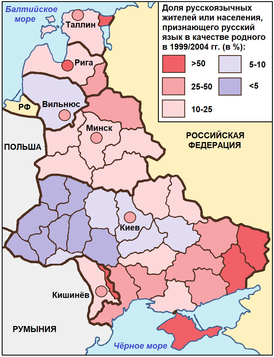
- In the post-Soviet time, the ethnic space of Russians in neighbouring European countries has noticeably ‘shrunk’, especially in Ukraine.
- Until the end of the 20th century, the share of ethnic Russians decreased mainly due to the out-migration from the Baltic countries and Moldova, as well as due to the changes in the ethnic identity of the Russian-speaking population in Belarus and Ukraine.
- In the 2000s, the outflow of ethnic Russians from the Baltic countries continued, being the most significant in Latvia and minimal in Estonia.
- With the approval of Russian as the second state language in Belarus in 1995, the size and proportion of the population recognizing it as a native language increased.
The article presents the analysis results of the Russian and Russian-speaking population dynamics at the state and regional level of the European CIS countries (Belarus, Ukraine and Moldova) and Baltic states (Estonia, Latvia, Lithuania) in the post-Soviet period. In accordance with the population censuses in these countries, the study interval is divided into two periods: the last decade of the 20th century and first decade of 21st century. The 1990s were characterized by a significant outflow of the Russian population from the Baltic states and Moldova, and a decrease in the proportion of Russians due to a change of ethnic identity in the Republic of Belarus and Ukraine. In the first decade of the 21st century, the outflow of Russians from the Baltic states continued, it was the most significant in Latvia, the minimal in Estonia. In the Republic of Belarus due to the Russian language adoption as the second state language in 1995 there has been a significant increase in the number and proportion of the population that recognizes Russian as mother tongue. The analysis results of the dynamics of Russians’ proportion are viewed through the prism of the concept of geo-cultural space. According to this concept, the Russian population proportion can be the quantitative criterion for distinguishing the components of the Russian geoethnocultural system territorial structure, which has experienced significant “shrinking” in the post-Soviet period.
Belgorod is one of the earliest and most prominent examples of the development of Western-style suburbanization in post-Soviet Russia. Based on the analysis of satellite images’ time-series, we traced dynamics of Belgorod suburbia development, and determined factors of its localization. We propose a method to interpret types of suburban settlement patterns (e.g. a system of the elements’ interpretation) and identified main shortcomings. A key feature of the rapid suburbanization of Belgorod during the post-Soviet period was the formation of extensive suburban sprawl areas, which are completely morphologically different from traditional seasonal (dachas) and rural single-story suburbs. Sprawl expansion on this territory occurred in two distinct waves, the first of which was induced by an influx of ethnic-Russian migrants from the near abroad, and the second coincided with the period of relatively high rates of economic development of Russia and Belgorod oblast in the 2000s and began to decline in early 2010. Growing systems of genetically related sprawling areas form tree-like graphs (due to the requirement for access to utilities and to the major transportation routes), the roots of which are the areas of high-rise buildings, and the leaves—younger “generations” of sprawling areas.
Theory and Social Functions of Geography
- With strengthening eastern vector of Russia’s development, inter-regional and cross-border cargo transportations in the Russian Far East (RFE) are growing.
- Provision of export-import cargo flows is the most demanded function of the RFE regional transport system.
- A comparative analysis of 16 land border checkpoints shows the primary demand for rail links.
- New railway crossings and modernization of existing ones on the Russian-Chinese border are needed.
The paper identifies and discusses various spatial forms and structures of conjugation of transport networks of the Russian Far East (or Pacific Russia) and neighboring countries. It is noted that in the context of the Russia’s focus on balancing its foreign economic relations between the “Western” and “Eastern” directions, the effective interfacing of its Far Eastern transport networks with the networks of neighboring countries becomes an important task. A comparative analysis of freight traffic through the existing transport networks’ conjugations (rail and road) and checkpoints at border areas is carried out, and the transformation of some of them into the international transport corridors (ITCs) is proposed. The necessity of high-speed ITCs’ network forming within the Far East and the border crossing points development at the state borders corresponding to the modern technical and informative level (ensuring the transportation of increasing volumes of transit and regional export-import cargoes) is justified.
Natural Processes and Dynamics of Geosystems
- In a century scale the stability of arid zones in European Russia is determined by the mutual compensation of anomalies of the annual humidifying, preventing the systematic increase in aridization.
- The frequency of spring droughts decreased in all the regions. The frequency of summer droughts was the highest in the period 1931–1960 in Rostov and Volgograd regions. In the period 2001–2012, there were an increase in the intensity of spring droughts and a decrease in the intensity of summer droughts in all the regions.
- The longest growth of aridization was observed in the Orenburg (12 years), Saratov and Volgograd regions (11 years). Shorter series of droughts, of 4 to 6 years, were typical for the Republic of Kalmykia, Volgograd, Astrakhan, Rostov, and Stavropol regions.
Secular trends in humidification in seven southern regions of the European part of Russia were investigated. Land degradation trend was assessed based on satellite albedo data at the beginning of the current century. Mutual compensation of intra-centuries fluctuations of the aridity index drives to the stability of arid zones in drylands. The insignificance of linear trend of the aridity index for the period 1901-2012 does not confirm the hypothesis of systematic strengthening of the aridization under ongoing global warming. The analysis of dry and wet years’ groups of the different duration revealed the decrease of the frequency of spring droughts, and their intensity achieved the maximum in 1981-1990. Frequency and intensity of summer droughts increased during the periods corresponding to the groups of growing aridization years. In the progress absence in aridization of drylands of the European part of Russia for more than 100 years, increased land degradation becomes the dominant factor of desertification.
- The aggregated database of vegetation, soil and slope characteristics of the Western Sayan region as parameters for hydrological modelling was created.
- Agreement between modelled and observed hydrographs of daily water discharge allowed for an assessment of the long-term average runoff from the different run-off complexes and their contribution to the formation of mountain rivers drain.
- An effect of different forest types characteristics, e.g. species composition, tree crown cover, slope steepness, soil, and vegetation, in the runoff forming was quantitatively confirmed.
- Revealed inconsistency of the runoff modules, changing with altitude, related to the features of snow storage in the upper levels of drainage basins.
Runoff estimation of drainage basin’s different spatial structural parts is presented in the research. The hydrological role of runoff-forming complexes is considered by the case study of the northern macroslope of the Western Sayan Mountains. The aggregate database of vegetation, soil and slope characteristics (hydrological parameters for modelling) was received during of investigated region’s analysis. The base’s applicability is justified by high results of calculated and obtained daily water discharge hydrographs’ convergence. An effect of different forest types characteristics (species composition, tree crown cover, slope steepness, soil, vegetation and other) in the runoff forming was quantitative confirmed. Water discharge is mainly provided by taiga geosystems which are prevail in water catchment areas investigated. According to the assessment of drainage basin different parts’ contribution to runoff the largest runoff modules and rates per unit of area are observed in nival geosystems and mountain tundras. Inconsistency of the runoff modules changing with altitude related to features of snow storage in the upper mountain levels of the Sayan Mountains’ northern macroslope was revealed.
- Changes in the species composition and spatial distribution of the Black Sea, the Sea of Azov and the Caspian Sea macrophytobenthos are cyclical and are associated with fluctuations in temperature, transparency, and salinity.
- The largest changes were observed for commercial species: expansion of the Zostera (the Sea of Azov, the Caspian Sea), degradation of the Cystoseira and Phyllophora communities (the Black Sea).
- The maximum destruction of macrophytobenthos in the Black Sea is observed in marine estuaries, namely port waters, such as the Novorossiysk Bay.
- Mathematical models of the response of water and coastal vegetation of the Northern Caspian Sea to changes in environmental factors allow for predicting damage to water bioresources due to climate changes and economic activity.
The concept of Large Marine Ecosystems assesses the state and dynamics of long-term changes in qualitative and quantitative indicators of macrophytobenthos (macroalgae and seagrasses) of the Russian southern seas. It is shown that changes in the species composition and spatial distribution of macrophytobenthos of marine ecosystems (the Sea of Azov, the Caspian Sea) are associated with fluctuations in salinity and sea level. For the Caspian Sea northern part (Russian sector) since the early 2000s. there is an increase in the share of sap-robial complex of green and red algae, the expansion of the habitat of Zostera noltii, due to changes in salinity and water level in the reservoir. The greatest destruction of macrophytobenthos in the Black Sea observed in marine estuaries, port areas, including in Novorossiysk Bay. The most resistant to the action of petroleum products are brown algae (Cystoseria), less green (Ulva) and red (Ceramium). Mathematical models of the Northern Caspian water and coastal-water vegetation response to changes in water level and salinity are constructed. These models adequately reflect the ongoing natural processes and allow to predict the impact of climate and anthropogenic load (economic activity) on aquatic biological resources. The necessity of the macrophytobenthos ecosystem “services” assessment for the Russian economy is pointed out.
- Primary succession of vegetation cover is observed on the waste piles of coal mines.
- Slopes of waste piles are colonized extremely slowly.
- Pioneer plant groups, simple and complex phytocenoses are found on levelled spoils and foreslopes (colluvial).
- Calamagrostis epigeios, Equisetum spp. and Convolvulus arvensis are tolerant to acid water flows.
- Succession goes in Calamagrostis way or mixed-herbs way up to the stage of complex phytocenosis.
The paper describes vegetation successions that can be observed on waste piles of Moscow lignite basin. Characterization of succession are performed with geobotanical descriptions that were made at non-recultivated waste pile, levelled dump and phytomeliorated waste pile. ^lonization of coal waste piles by plants corresponds to primary succession that proceeds in specific edaphic conditions. Term and trajectory of this process on waste piles of Moscow lignite basin in the Tula oblast differ at various object types. The rate of revegetation is slowest at slopes of waste piles and levelled spoils, where only solitary individuals of ruderal species can occur. At levelled spoils’ surfaces and self-developing deluvial-proluvial foreslopes (which is forming at waste pile foot) pioneer plant groups, simple structured phytocoenoses and complex structured phytoco-enoses are discovered. Most common tree species in simple structured and complex structured communities is Betula pendula. Under the toxic flow influence herbaceous layer at deluvial-proluvial foreslopes and in certain parts of levelled spoil consists mainly of Calamagrostis epigeios, Equisetum spp., Convolvulus arvensis. Out of toxic flow influence at levelled spoil forb meadows with large proportion of legumes (Trifolium hybridum, Lotus corniculatus, Melilotus albus etc.) occur. Succession stages changing is not rapid and revegetation processes takes decades; the phytomelioration of Moscow lignite basin waste piles in the Tula oblast can speed this process up by overcoming the delayed pioneer plant groups stage. The pattern of plant succession trajectories on waste piles of Moscow lignite basin in forest-steppe landscapes of the north part of the Central Russian Upland was developed.
Evolution of Natural System
- 5 stages of valley landscape development for the last 5.9 ka under humidity changes have been identified.
- During the dry period 2.7–1.3 ka BP, buried soil was formed on the high floodplain.
- Floods became more frequent during the existence of the Bohai Starorechensky hillfort.
- The Little Ice Age was characterized by high moisture and frequent intensive floods.
- The presence of ruderal plant pollen indicates human impact on landscapes in the Middle Ages.
Landscapes’ development in the Razdolnaya River Basin in the Starorechensky hillfort vicinity was reconstructed. Fragmentary data for the middle Holocene phase (~5.9 cal. ka) were obtained, in detail the reconstruction was carried out for the last 2.5 cal. ka. The development of landscapes took place in contrasting climatic conditions, moisture changed the most strongly. Five stages of the valley development under different humidity were reconstructed. The sections include buried soil formed in the droughty period in the second half of the late Holocene. At this time, steppe sagebrush, mixed herbs grasslands and birch woodlands were widespread. Climate in the late 7th-10th centuries gradually became warmer and more humid. Decrease of the temperature, with high humidity in the Little Ice Age with a constant renewal of the substrate on the floodplain during floods, led to an increase in areas occupied by Betula ovalifolia communities. The role of Pinus densiflora and birches increased in the mountain forests. Correlation of paleogeographic events with regional data is carried out. The role of the anthropogenic factor in the development of landscapes during the settlement of the valley by the Bohai agriculturalists, the first settlers of the 19th-beginning of 20th centuries and the development of modern agro-complexes was analyzed.
Natural Recourse Use and Geoecology
- Bottom sediments of the Eastern Donbass rivers are represented by poorly differentiated psammite–aleurite–pelite matter.
- Priority pollutants of bottom sediments are chromium, copper and zinc. Their amount exceeds significantly the regional background numbers.
- The level of pollution of river sediments is low for all the rivers of the Seversky Donets basin, low or medium in the Tuzlov basin rivers.
- Under certain conditions, the bottom deposits of the Eastern Donbass rivers can be a source of secondary contamination of the surface water by Mn, Fe, Cu, Cr and Li.
- The assessment of the potential risk of secondary contamination of river waters is based on the mass of elements potentially available for transition to river water and stream discharge of the river.
For the first time for East Donbass coal-mining areas the material structure and impurity levels of small and average rivers’ bottom sediments were studied. Data of a wide range of heavy metals and minerals in bottom sediments and in the pelitic fraction (<0.01 mm), which is the most informative at assessment of river alluvium impurity degree, are obtained. As the made model experiment result data on region bottom sediments as aquatic environment secondary pollution source are obtained. It is defined that under certain hydrodynamic conditions such as wind resuspension, water discharge change, dredging etc. region river sediments can be a secondary water pollution source with compounds of manganese, iron, copper, chrome and lithium. The rivers were ranked according to the secondary pollution danger’s degree and negative impact on water quality based on the scoring method. The obtained data showed that the major part of the region rivers are characterized by medium and low levels of potential impact on the rivers aquatic environment.
Regional Geographical Problems
- Ski resorts become one of the major specialities of the Ural tourist industry. At the moment, about a hundred ski resorts are functioning here.
- The growth in a number of ski resorts in the region peaked in the first decade of 21st century.
- Ski resorts are concentrated in the Middle and Southern Ural, spanning over four regions: Perm Krai, the Republic of Bashkortostan, Chelyabinsk and Sverdlovsk regions.
- Most of the resorts are located at a significant distance from the regional capitals, near other large or medium-sized cities.
Ski specialization of the Urals is becoming more and more noticeable. This tourist-recreational sphere develops in the wooded areas of the Mid Ural, Southern Ural and surroundings. Traditions established during the Soviet period, a significant proportion of urban and highly educated population, suitable natural resources, location of the large industrial cities in the Ural Mountains are factors contributing to the development of this service sector. Since the activities of ski resorts are highly dependent on a variety of conditions and components (geomorphological, climatic, landscape-ecological, positional, transportation, infrastructure, service, etc.), the methodology of their research must consider the numerous characteristics. Among the one hundred of ski resorts currently operating in 11 regions of the Urals, three-quarters are located fairly dispersed in four regions: Perm krai, Sverdlovsk oblast, Chelyabinsk oblast and in the Republic of Bashkortostan. Perm krai is the leader in the Urals by the number of ski resorts. Almost half of all ski centers in the Perm krai are located near Perm, but the largest complexes are located further 150 km from the regional center in the Middle Urals. Small enterprises are in the southern part of the region within the boundaries of non-central cities and in rural areas. Within the main cities of the Greater Urals, there are 9 ski resorts providing daily services, 25 are in the 10-60-kilometer zone from the capitals. The largest number of ski resorts (46) refers to those located at a distance from the administrative centers of the regions, but geographically tied to cities of considerable size. In rural areas of the Urals, 14 resorts operate. The geographical features of the ski resorts’ network compel us to consider this activity as one of the main future sectors of tourism in the Urals.
- Changes in hydrological and chemical indicators are important for adjusting rules for the regulation of the river flow by a cascade of reservoirs.
- Changes in runoff led to the depletion of water in the lower reaches of the river by suspended solids due to their accumulation in the reservoir.
- Incorrect regulation leads to a general delay in the peak of flood for 45–50 days; the minimum mineralization is 0.26 g/l in July–August.
- Maximum discharge at dangerous marks of 620–670 cm can lead to irreversible processes.
One of the features of our time is the general deterioration of the aquatic ecological situation, the cause of which is often anthropogenic activity amplified by changes in natural factors. Using the temporary analogy method, hydrological and hydrochemical indicators of the water regime of the Volga lower reaches are compared for periods that differ in the degree and nature of anthropogenic impact. The Volga lower reaches refer to the territory, including watercourses of the Volga-Akhtuba floodplain, delta and Western steppe ilmens belonging to the Lower Volga and considered by the authors within the Astrakhan oblast. Data on the total annual runoff and its annual redistribution make it possible to identify the ratio of anthropogenic and natural factors’ contribution to its formation. The regulatory effect of reservoirs in which river water from the entire catchment of the river accumulates, their mixing and the chemical composition final formation, lead to irreversible consequences and natural processes manifestations.
- Aksu-Zhabagly is the oldest nature reserve in Central Asia (94 years).
- The conservation regime affects all types of mountain terrain in the Western Tian Shan.
- The prevailing trend is towards stabilization or termination of geomorphological processes.
- An exception is landslides in tectonically active zones triggered by increased moisture.
- There is a slight activation of gravitational processes in the alpine highlands.
The oldest nature reserve in the mountains of Central Asia Aksu-Zhabagly Nature Reserve was created more than 90 years ago. During this period, the conservation regime had a significant impact not only on biota, but also on exogenous processes in the reserve. In order to assess this influence, the staff of the Institute of Geography RAS conducted special geomorphological studies. A typological zoning of the reserve’s mountain relief was carried out in all high-altitude tiers: highlands, middle mountains and lowlands. A transitional zone characterizing large tectonic benches has been identified. For each type of relief, characteristic changes in the course of geomorphological processes associated with the cessation of anthropogenic pressure, mainly in the form of grazing and the establishment of a specially protected area, are determined. It was established that the general tendency to stabilize the slopes prevails, more noticeable in the mountains’ lower tier and practically absent in the high mountains. The reverse trend to processes intensify is noted in two geomorphological settings: in the Alpine highlands and in the foci of landslide development in the transition zone from the highlands to the middle mountains.
View of a Geographer
- Baikal is the most important part and natural resource of Eurasia and Russia.
- The region is a cultural symbol and integrator of the Russian space.
- The ecological problem of Baikal is global, culturally and ethically loaded.
- The realization of the right of common access to Lake Baikal means its killing.
- Baikal problem would be a milestone decision for Russian society and the state.
The article concerns with a bundle of Baikal region problems in relation to global processes. These problems are not formulated distinctly yet. Baikal region is at once a critical part of Eurasia and Russia, important natural resource, one of the few globally significant territories in Russia, notable for highest grade of biodiversity and landscape diversity, a place of great geopolitical and geostrategic significance, indicator of social habits, sacral symbol of Russia. The basic cultural, legal and ethical clashes essential for recognition of the problems are detected. The ecological problems of this unique territory are immersed in both cultural and global context. A draft concept of Olkhon Island maintenance is given.
- Elements of a green economy are historically organic to Russian urbanization.
- Thanks to digitalization, all 10 sectors of the green economy can provide breakthrough effects in ensuring sustainable development of urbanized areas.
- The integration of digital and green economies creates opportunities for the development of new industries and improving the quality of the urban environment.
- An adequate spatial form for the implementation of the green–digital mode is the multiscale polarization of urbanized areas.
The article proposes an original typology of the Sustainable Development Goals (SDGs) 2030, which allows formulating through other SDGs methods and criteria for sustainable development of cities (SDG-11). Due to digitalization, all of the 10 branches of the green economy can give breakthrough effects in ensuring the sustainable development of urbanized territories. Although elements of the green economy are historically organic to Russian urbanization, it is not possible to solve the main problem of sustainable development of Russian modern spatial development—the growing contradictions between the trends of hyperconcentration of population and economy in a small (for the size of Russia) number of megacities and their critical deconcentration on the periphery—on the existing technological basis. Nevertheless, the consistent implementation of technological capabilities based on the integration of digital and green economies creates opportunities for significant productivity growth in infrastructure and production sectors of cities and development of knowledge economy and experience economy, while improving the quality of the urban environment and the quality of urban life and achieving sustainable development. A consistent and balanced multi-scale spatial-temporal and functional polarization of urbanized territories is an adequate form of implementation of this technological order. It allows on the basis of deepening the geographical labor division and coordination of the turnover of material, natural and human capital to solve the problems of sustainable spatial development of Russia by harmonizing its environmental, economic and social components. The principles of spatial-temporal, morphological and functional polarization are manifested in various spatial levels. With the development of indicators’ set and the expansion of the statistical base for the analysis of the green economy, the spread of smart city technologies and lifecycle management of land use, the constructive-geographical, project approach in urban planning, in ensuring the sustainable development of cities and agglomerations in Russia will become as familiar as the prevailing research approach.
ISSN 2658-6975 (Online)


