

Theory and Social Functions of Geography
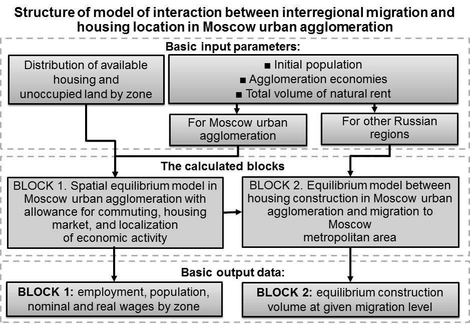
- There is positive feedback and equilibrium ratio between migration inflow and housing construction in the Moscow agglomeration.
- In the 2000s, an ability of the Moscow agglomeration to accumulate migration fell by half in comparison with the 1990s.
- Outside the Moscow Automobile Ring Road (MKAD) the share of non-residents homebuyers is twice higher than in Moscow and reaches 25–35%.
- Housing construction in the 30-km zone outside the MKAD is a key regulator of migration balance at the national level.
Housing construction inMoscowagglomeration is a key mechanism stimulating migration inflow because it forms a downward pressure on housing prices, which are the most important barrier for migration. Positive feedback between extensive way of development of theMoscowagglomeration and migration inflow into the capital region stimulates hyperconcentration of the population and economic activity. Theoretical analysis shows that there is equilibrium between housing construction and migration inflow to theMoscowregion. According to our estimates, in the 2000-s the relation of migration inflow to housing construction volume (capability of theMoscowagglomeration to accumulate migration) has halved in comparison to the 1990s. Mathematical modeling and empirical data show that this shift was determined by the increase in natural rent distributed inRussiaand in agglomeration economies in other major cities of the country. Especially favorable for migration inflow is oil-spot-style extensive way of development of the agglomeration due to the dominance of largegreenfieldprojects of affordable housing in the 30-km zone outside the Moscow Ring Road in housing construction. It is shown that the development of this zone is a key regulator of the migration balance at the national level. Extensive way of development is subsidized by the government through multiple channels, primarily investments in transport infrastructure, what contradicts official goals of the regional policy and the government efforts to mitigate interregional inequality through the fiscal redistribution.
Territorial Organization of Society
- History of formation of geography of services.
- Mathematical tools to estimate the structure of the tertiary sector of the economy.
- Structures of the tertiary sector of Eastern European economies (Hungary, Czech Republic) generally reflect the structure of the tertiary sector of the world economy.
The research of tertiary sector of economy is becoming one of the most attractive topics in the modern socioeconomic geography. One of the key issues is the choice of mathematical research tools. Sometimes a researcher faces the need of creating own mathematical tools. Tools are often presented by the parameters (indices, coefficients), used to analyze different sides of the intangible production sphere. In the article, author’s methodology for assessment of tertiary sector structure of the world economy is given as an attempt to penetrate to the internal arrangement of service sector. The tertiary sector (the services) is a very heterogeneous subject of economic activity types, united only by the quality of immateriality. The economic and mathematical tools developed by the author make it possible to produce country comparisons by tertiary sector, as well as to put forward hypotheses about the key segments development. The interpretation of the obtained results is given. Also, the author pays special attention to the theoretical and methodological basis of the geography of tertiary sector.
Natural Processes and Dynamics of Geosystems
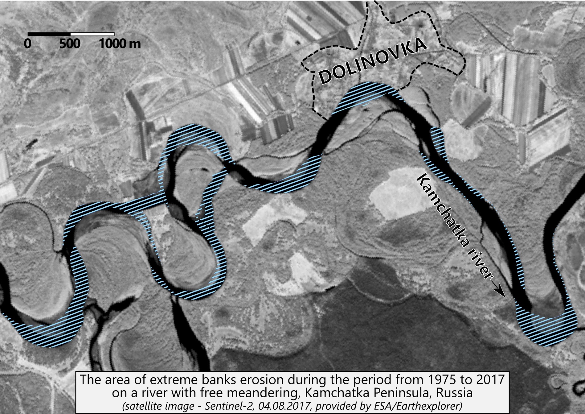
- Extreme processes are characterized by rates and duration of development, far exceeding the mean maximum values.
- Specific processes occur in conditions that are different from those typical for a given natural zone, region, river or channel form.
- The classification of extreme processes in terms of scale, frequency, dangerous consequences and other factors.
- Typical examples of the various natural forms of extreme and specific processes.
This paper represents definitions of extreme and specific manifestations of channel processes and reviews relationships between themselves and connections with extreme or extraordinary hydrological situations. The main sign for referring channel processes as extreme is the anomaly of their manifestation, which is reflected in extremely high rates and duration of development (significantly exceeding the mean maximum values), unexpectedness of occurrence and difficulties or impossibility of forecasting. Specific channel processes occur in conditions of channel formation, which differ from typical for a river or rivers in the region and have limited distribution. Criteria provided to characterize the extremality or specificity of the manifestations of channel processes, their qualitative and quantitative assessments, as well as the analysis of hydrological, geological, geomorphological and anthropogenic factors of their origin and development are given. The spatial scale of manifestations, their frequency, negative social and economic consequences and the possibility of prevention are considered. An approach to the classification of extreme and specific channel processes and the evaluation of their risk to economic activity is proposed. Typical examples of extreme and specific manifestations of channel processes in various temporal and spatial scales and natural zones are shown.
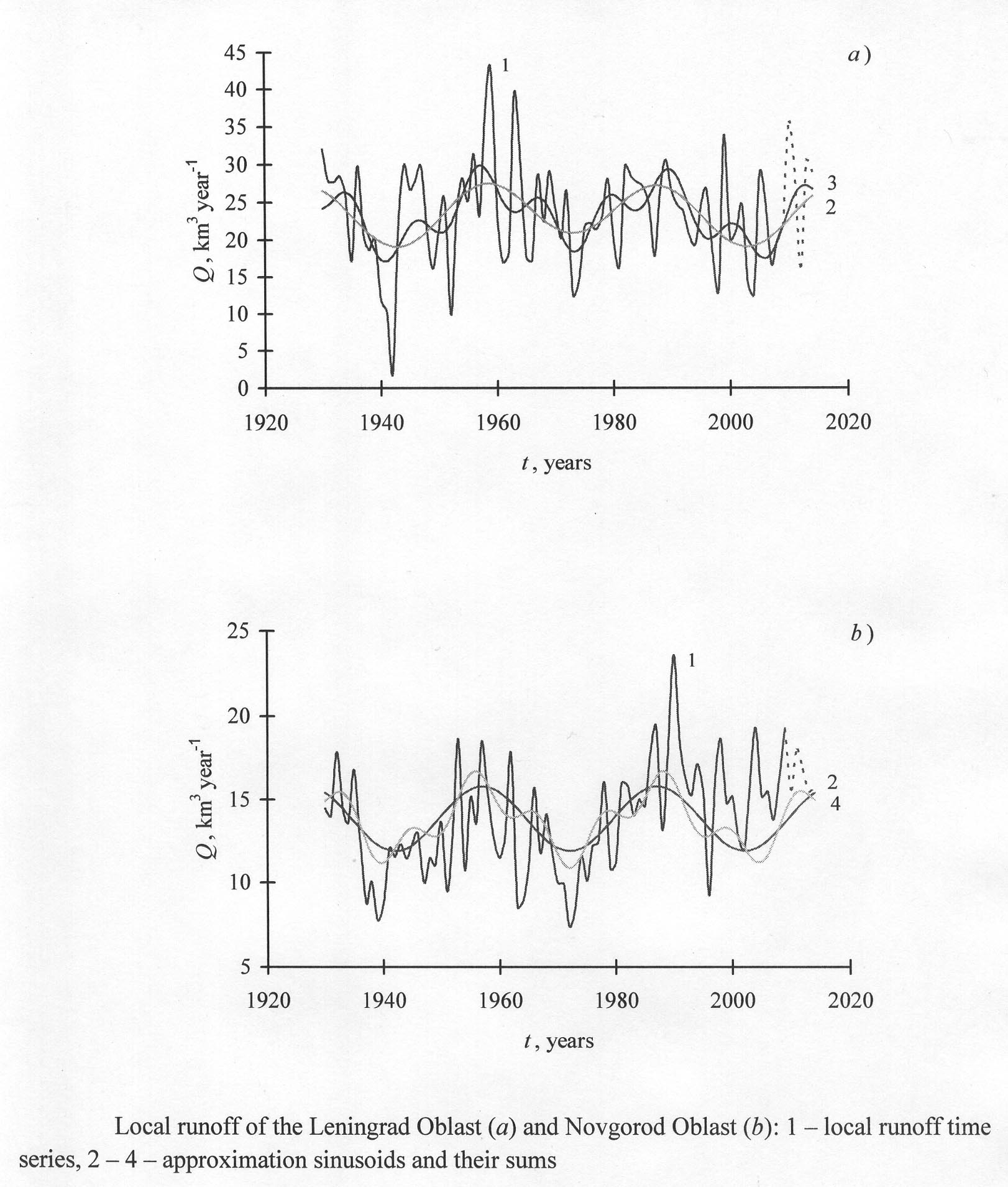
- In the variations of the local runoff the periods of 4, 8, and 11 years long are most frequent.
- The regularities of lag time of harmonics in runoff time series permit to improve its forecasts.
- The training of the forecasts by the combination of sinusoids with long and 11-year long periods is most efficient.
The time series of waters of local formation of federal subjects of theNorthwestern Federal Districtare analyzed by the method of the “Periodicities”. The periods with the length of 4, 8 and 11 years are repeated in these time series more often than the others. The most times (8 from 10) are revealed the sinusoids with the period of 11 years. The training forecasts of the local runoff are computed with the lead time of 5 years by the sinusoids with these periods, by the revealed sinusoids with periods larger than 29 years (long periods), and by the combination of sinusoids with the period of 11 years and long periods. The results of the training forecasts are tested by the new independent data. The best forecast results are achieved by the combination of the sinusoids with period of 11 years and with long periods. The scheme of prediction with the best forecast results engages the sine with the period, revealed in the most number of time series of runoff of local formation. This points out for the expedience of estimation of the repetitiveness of the same periods in the different time series under analysis, modelling and forecasting waters of local formation both in the administrative and physico-geographical regions, for example, basins of rivers and lakes. The forecasting results may be improved if some regularities of time lag of sinusoids with revealed periods to each other will be found and applied for calculations of the future runoff.
Evolution of Natural System
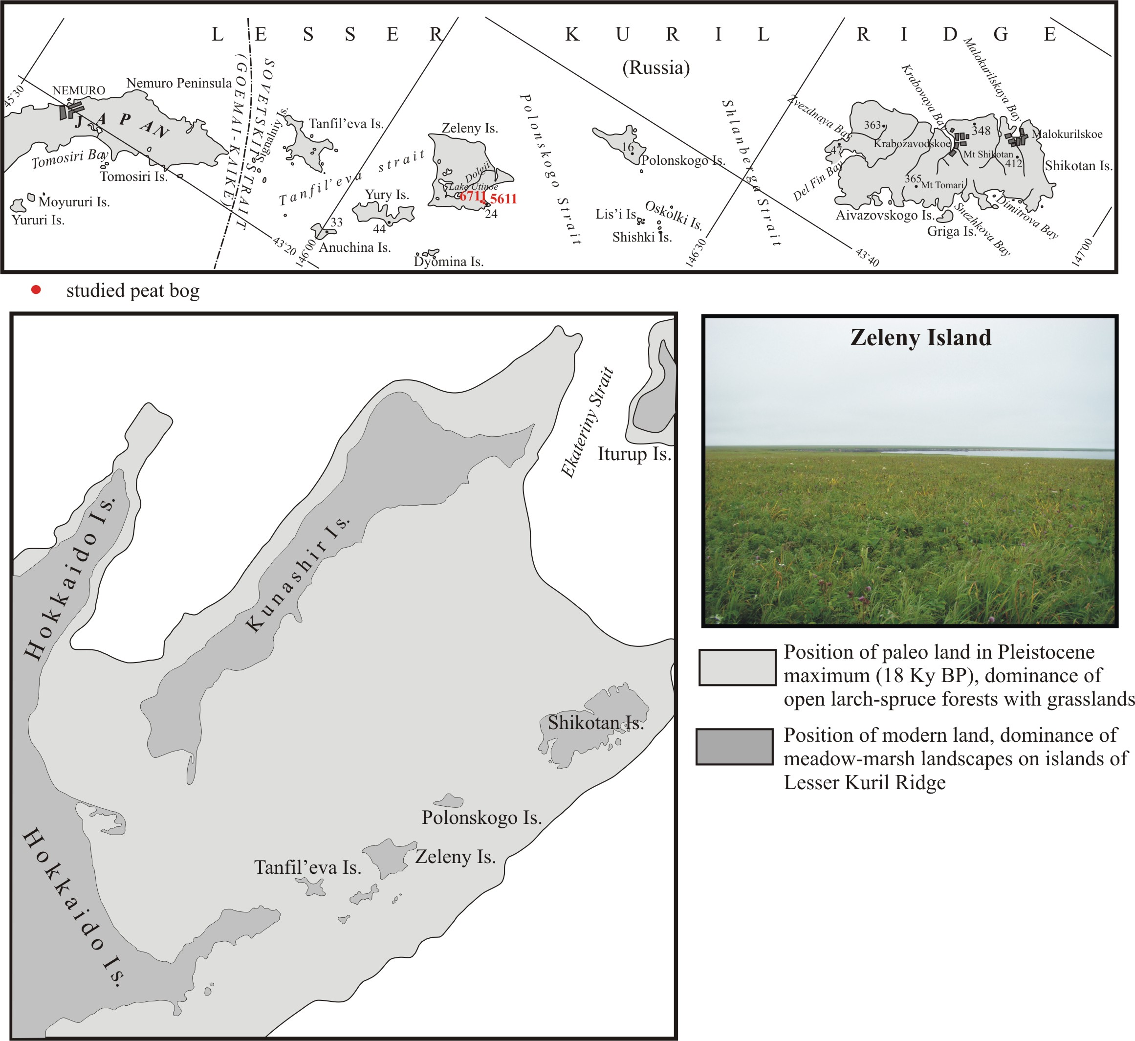
- The fragmentation of the land bridge was finished in the maximum of the Middle Holocene transgression.
- Landform features and increased impact of maritime climate restricted colonization of the species from the neighboring areas.
- Arboreal vegetation degraded rather quickly, meadow-marsh landscapes became predominant.
Аbstract. Based on comprehensive study of a pit bog on theRudnyaBayseaside (ZelenyIsland) stages of landscape development were reconstructed for the south of Lesser Kuril Ridge when an extensive land bridge connecting South Kuril Is-lands withHokkaidoIslandhad existed there. Fragmentation of the land bridge was finally finished in the maximal phase of the Middle Holocene marine transgression. This led to isolation of island’s flora and fauna. Features of the relief of Lesser Kuril Ridge and increase in oceanic climate troubled migration of species from neighbor territories. Woody vegetation degraded rather quickly. Meadow-marsh landscapes have become predominant. Other factors which affected subsequent development of biotic components are climatic fluctuations, tectonic setting which increased the level of groundwater, tsunami waves, strengthening the role of the cold Oyashio Current and the fall of the volcanic ash of Masu volcano. Changes in the landscapes of the Lesser Kuril Islands are in many respects similar to those on theNemuroPeninsula(Eastern Hokkaido).
Natural Recourse Use and Geoecology
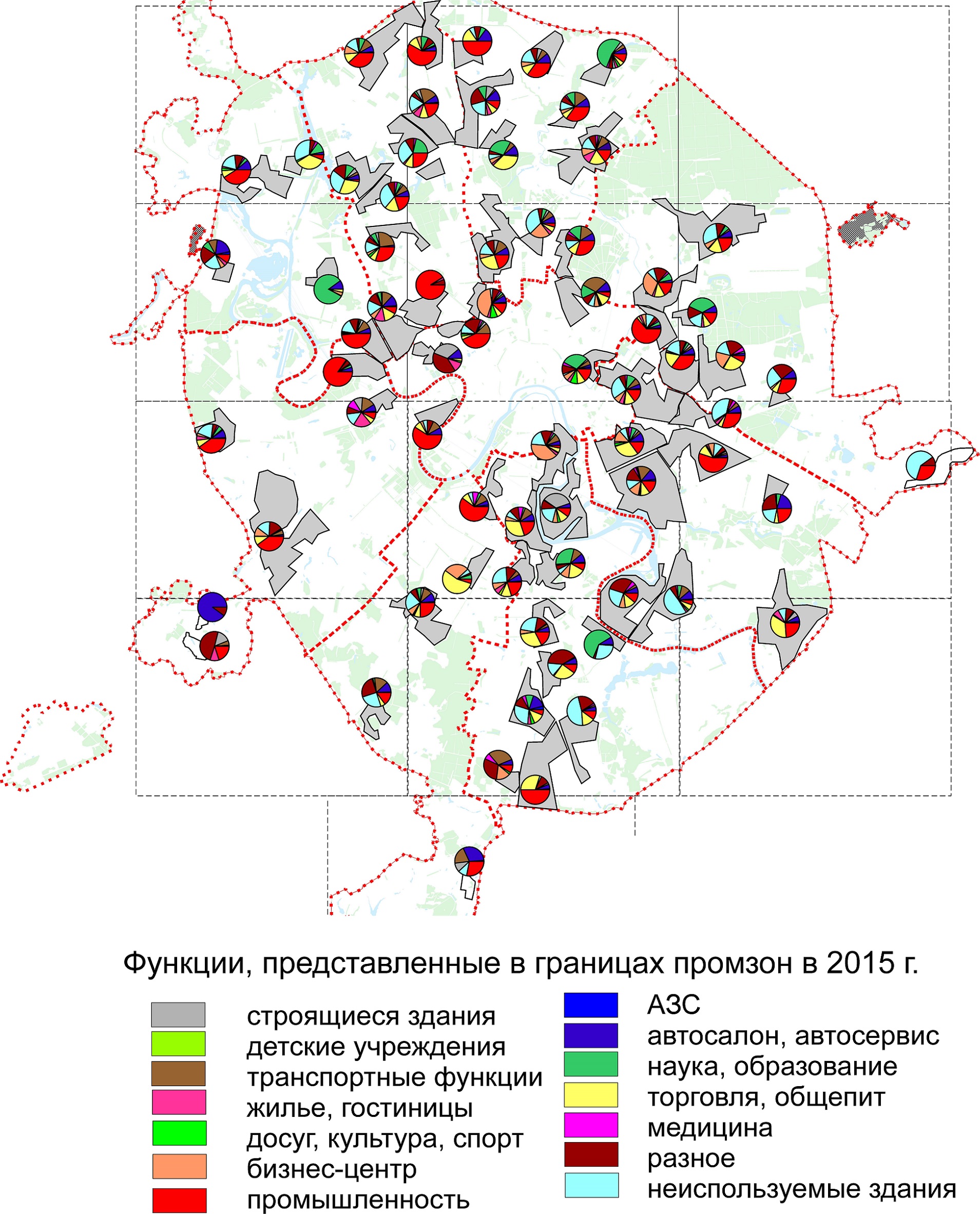
- Method of assessment of environmental intensity of the use of industrialized areas.
- Directions of reorganization of industrial zones reveal pronounced spatial conditionality.
- Changes in environmental intensity of land-use relate to varying volumes of off-gas release.
- The plans to reorganize industrial zones of the eastern part of Moscow were worked over in more details.
Considerable transformation of functions of industrial zones took place during the last decades inMoscow. Nowadays the main trends of reorganization for the industrial zones ofMoscoware science, trade, car selling and service, business and housing construction. The author’s methodology for assessment of ecological intensity of using of industrial zones based on potential environmental dangerous of their functions is presented. In case of it the functional zoning of each industrial zone is done. According to the methodology changes of impact level on the environment and trends of changing of the types of the industrial zones are revealed. The comparison of the results of the methodic and the changes of volumes of air pollution is done. Air pollution is the most changeable parameter of the anthropogenic influence. The most ecological directions of functional transformation of industrial zones and the territorial distribution of enterprises of different specialization are found. The key projects of the next renovation of industrial zones inMoscoware considered. The geographical specifics of the projects is studied. The vulnerable aspects of the projects are noticed
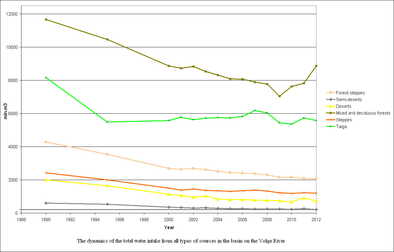
The regularities of the dynamics of indicators for water use in natural zones of theVolgabasin in the post-Soviet period (1990–2011) were found out. Three groups of such indicators were viewed: 1 – total water intake and water intake from surface and underground sources and the losses during transport; 2 – total water use and its use in various sectors of economy – housing and communal services and irrigation; 3 – wastewater discharge, including regulatory purified, contaminated and relatively clean waters and wastewater discharge on the terrain. In all natural zones and in the entireVolgabasin the significant reduction of total intake from all sources took place, by a mean of 35%. The decrease of all other indicators of water resources use was proportionally to the total intake: water intake from surface and underground water sources, water use in various sectors of economy, and wastewater discharge. The reduction in water use is mostly manifested in broad-leaved and mixed forests zone. The account of natural zonality in the use of water resources in river systems is essential for monitoring and designing the socioeconomic development of the territory
Regional Geographical Problems
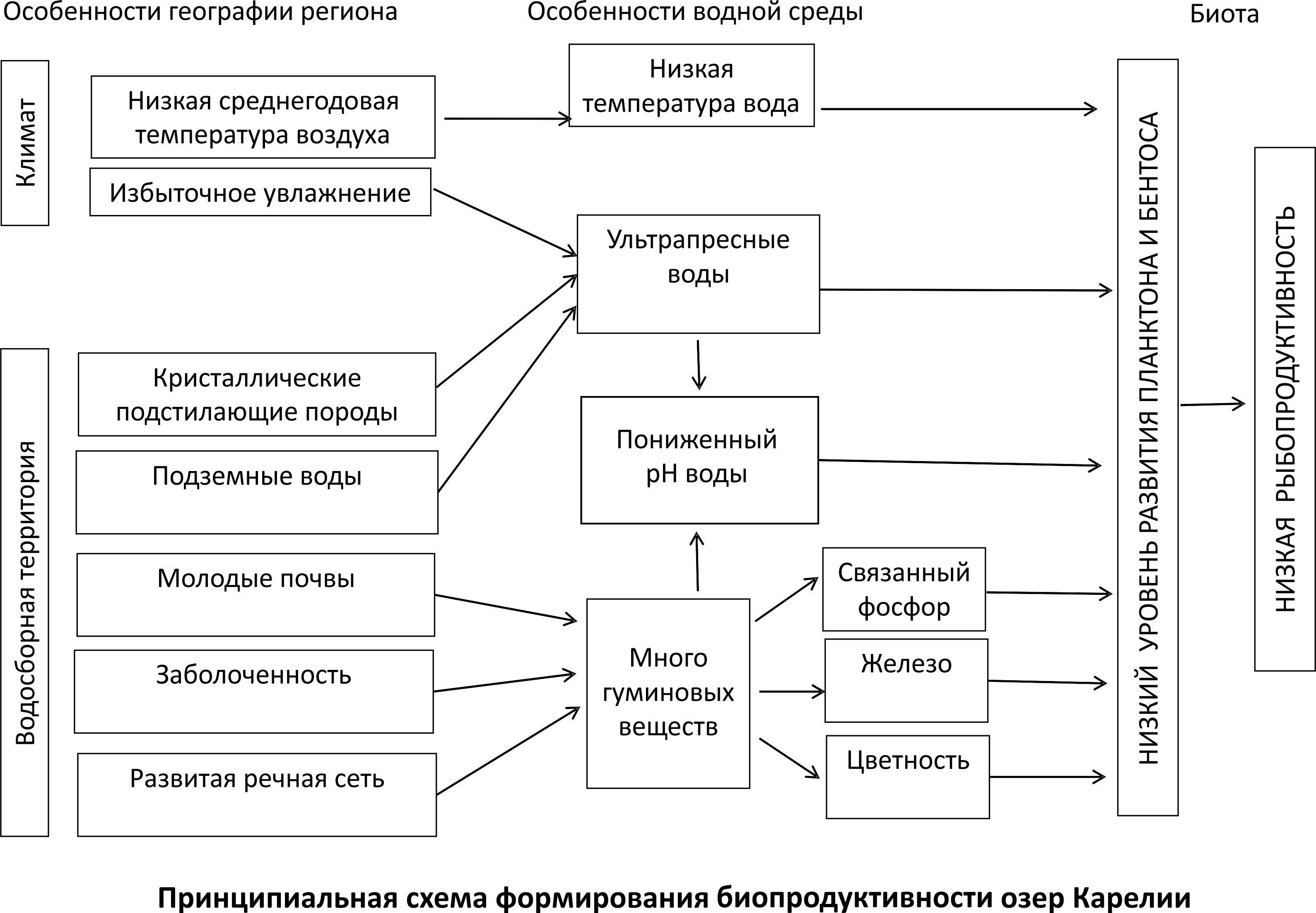
- The humid climate and postglacial landscapes determine the low biological productivity of lakes in Karelia.
- The limitation of fresh water biota by low TDS concentration, pH and phosphorus is statistically proven.
- The humic substances discharge into lakes depends on their flowage, inflow and the density of river network.
- Humic substances form a low pH, high color of water and supply chemically bound phosphorus.
- Crystalline bedrock determines the low TDS concentration in the water.
Multiple reported data on plankton, benthos, and chemical composition of surface waters and geology ofKareliaare summarized in order to reveal regional peculiarities of the formation of aquatic communities’ structure and biological productivity. A basic scheme for the biological productivity formation of water bodies inKareliais proposed. The main features of the humid climate ofKareliaare the low average annual air temperature and excessive humidification. The geographical features determine the specific physico-chemical properties of the aquatic environment, including low temperature, short vegetation period, low total dissolved solids (TDS), pH and phosphorus concentrations. Low water temperature and phosphorus concentration limit the development of highly productive forms of biota. Increased color of water diminishes the area of phytoplankton distribution. Low TDS concentration of water restricts the growth of diatom frustule and shell-bearing mollusks, which can limit the total biomass of plankton and benthos. Acid reaction of the environment can have toxic effects on aquatic animals. The proposed scheme was tested on seven lakes ofKarelia, located in different landscapes and differed in the degree of swampiness and density of the river network in the catchment area, in flowage, TDS concentration, color, pH, phosphorus concentration. The performed principle component analysis has statistically confirmed the regularities identified due to the generalization of reported information.
- The most likely scenario for the development of regional energy system is functioning in isolation.
- Network complexes of the regional energy system operate in an open mode in more than a half of the region’s area.
- Development of distributed energy gives opportunity to decentralize regional energy system and improve its reliability.
- The potential for hydro and wind power in the region reaches ⅓ of existing power plants capacity.
Review of variants of perspective development ofKaliningradoblast is performed. It is revealed that the functioning of the energy system in isolated mode is the most disadvantageous and, at the same time, a probable scenario. This variant is considered from the point of view of the oblast’s internal energy space organization. The analysis of the territorial organization of energy supply is based on the provisions of the mathematical graph theory. It was found that the main framework of the cyclic network of the regional energy system consists of 14 cycles. This is a zone of relatively sustainable energy supply. The rest networks of the regional energy system work in the open mode; this is an acyclic zone of energy supply ofKaliningradoblast. It is revealed that the treelike networks’ dominance zone taking more than a half of area ofKaliningradoblast is characterized by very low reliability of energy supply. A “multi-layered” model of territorial organization of the regional energy system is suggested, more reliable criterion of security of energy supply. In case of its implementation the local system can “lock” consumers in the local network cycle and own potential of small generation
- Total fresh water flow from the Murmansk coast ranges from 50 to 80 km3∙per year.
- Total solid flow from the Murmansk coast is estimated at 40–70 thous. t per year.
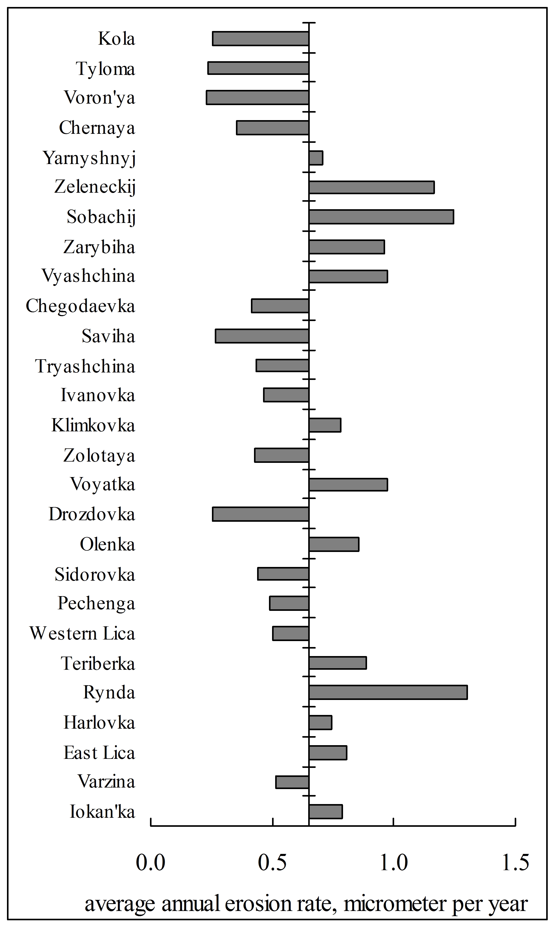
- The rate of erosion of the catchment areas of the Murmansk coast does not exceed 2 μm per year.
- The low rate of erosion is predetermined by the geological-geomorphologic structure of the territory and the geographic location of the region, but does not depend on climatic changes.
The water flow, module of suspended matter yield and speed of erosion of water basin area have been assessed on the basis of studying multiannual data on the water discharge and concentration of suspended matter in the waterways of the Murmansk coast. It is revealed that total flow varies in the range of 50–80 km3 ‧ y–1; transit and boundary river systems play the leading role in the flow. In recent years there is a decrease in water flow, maximum flow occurs during the spring flood and is 40–60% of the annual flow. It is found that the total flow of suspended matter from the coast is 40 000 to 70 000 t‧ y–1. The low module suspended matter yield (is less than 2 t‧ km–2 ‧ y–1) and slow speed of erosion (is less than 1.5 mkm‧ y–1) are predetermined by a geological-geomorphological structure of the territory and a geographical position of the coast, but do not depend on changes in average annual air temperatures and annual amount of precipitation in the region.
History of Geography
- During the expedition to Mongolia D. Klements studied and mapped earlier little-known regions of the Gobi Altai.
- He made a big contribution to geological study of Mongolia, in particular, discovered volcanic activity, erstwhile observed in South Khangai.
- Large collection of minerals, flora and insects was gathered.
In article, the author based on documents from archive depositories of Tomsk and Irkutsk, which are earlier not introduced for scientific use, and also little-known articles, letters and scientific reports of D.A. Klements, considers the poorly studied questions in scientific literature connected with the geographical researches conducted by D.A. Klements in Mongolia on the instructions of Academy of Sciences in 1891–1896. Methodological base of work is intellectual history based on studying of all aspects of history of ideas and interaction between such subdisciplines as history of natural, social and human sciences. Using this methodology the author has made an attempt to analyze and show through a prism of studying and assessment of forwarding work of D.A. Klements in Mongolia, how his scientific views on a number of the problems connected with geology and archeology of Mongolia, which had not been studied yet, and also on the system of studying of this region of Central Asia were forming. The author traces the aspects of D.A. Klements’ research works connected with botany, meteorology, glaciology and volcanology, and considers his newspaper journalism devoted to the Mongolian. His concrete contribution to geographical studying of remote and earlier poorly studied places, such as Khangai, the Gobi Altai, riverheads of Selenga River, including the topography and mapping the area, the analysis of its geological structure, and collecting fauna and flora, is estimated.
View of a Geographer
Yuri Medvedkov was one of the most glittering figures in the Soviet geography of 1960–1970. He was one of the standard-bearers of the quantitative and theoretical revolution. He brought in the geography not only the extremely valuable results and methods of modeling, but much more strict way of thinking, which is peculiar to the exact sciences. The level of theoretical thinking in geography has decreased significantly over the last half century and we are sorely behind the level of the Dr. Sci. thesis of Yu. Medvedkov. Medvedkov has created in1974 intheInstituteofGeographythe Laboratory of human ecology, which became for several years one of the most vibrant centers of geographical thought in our country. In 1972, Medvedkov was deprived by the arbitrary of power to return toGeneva, where he headed the Laboratory of ecology of WHO. After this he was deprived of the opportunity to travel abroad. Such a problem finally forced him to submit in 1981 the statement on emigration. He was excluded from the scientific community until his emigration in 1986.
ISSN 2658-6975 (Online)


