

No 3 (2018)
From the Editor-in-Chief
Territorial Organization of Society
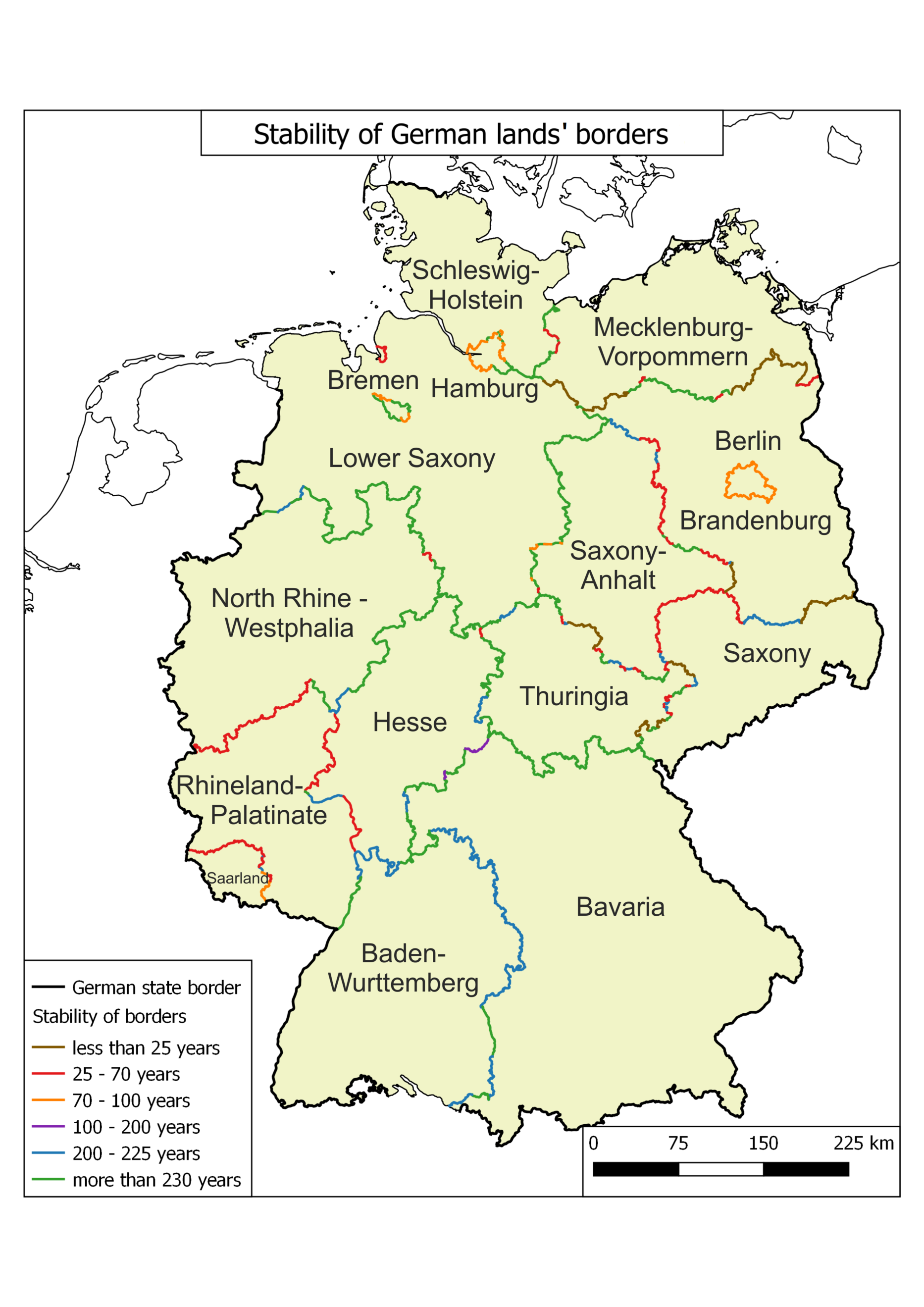
- German Lands’ (states’) boundaries remained stable during the federal periods. Federative structure, broad powers of the Lands’ authorities and traditional communities prevented their reformation.
- Lands were reformed constantly during the period of centralization in 1930s and the occupation time in 1946–1949.
- Borders of the Lands remained stable mainly in the central Germany, while they could be changed in the West and the East of the country.
- There is a small pulsation trend in changing of the system of the country’s governmental districts and of provinces of Prussia.
- In spite of the pulsation, many of them remained stable for more than 200 years. Their stability is explained by the established structure of administrative and economic relations and the settlement system.
26-36 1716
Abstract
This article presents the historical and geographical analysis of evolution of administrative division of Germany at the levels of lands, provinces of Prussia and administrative districts for 1871–2017. Spatial patterns of changing administrative division are revealed, the assessment of stability of administrative units of the country is carried out. The article answers to the question whether the pulsation occurred: alternately increasing and decreasing the number of units. Three indicators were taken into account to quantify the change in the administrative grid: number of units, their median area and an index of shape. The lands remained stable during the period of the federative state and were reformed constantly during the centralization of the country and during its occupation after the Second World War. There are three waves of consolidation of lands, the wave of breaking up into smaller units is not revealed. Borders of lands remained the most stable in the center of Germany, they are the least stable in the West and the East of the country. There is a small pulsation in changing of the number of provinces of Prussia and districts. The consolidation of units was evoked by economic crises, under the influence of which the authorities created administrative units with great economic and demographic potential. Breaking up into smaller units took place during the rapid economic development of the country. Despite the pulsation, many districts and provinces remained stable. It is explained by the established structure of administrative and economic relations and the settlement system.
Theory and Social Functions of Geography
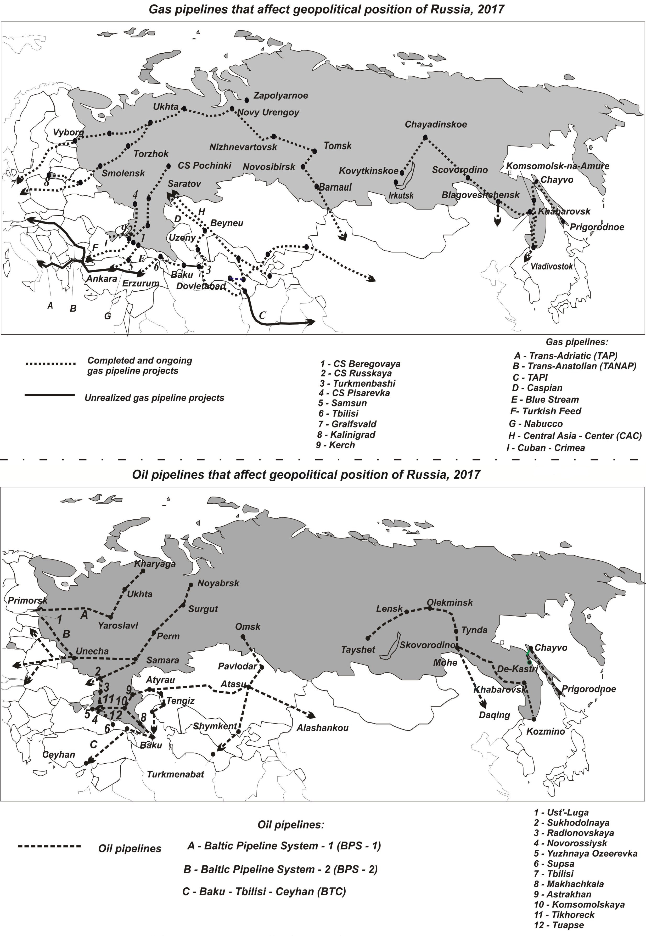
- One of the main transport and geographical problems in the post-Soviet space is the dependence of energy-exporters, including Russia, Azerbaijan, Turkmenistan, and Kazakhstan, from transit-countries such as Lithuania, Latvia, Belarus, Ukraine, and Russia.
- An intention to reduce/exploit this dependence turns transport routes (mainly pipelines) and elements of transport infrastructure (mainly seaports) into one of the major foreign policy instruments of the post-soviet states.
5-17 3595
Abstract
The paper presents the outcomes of a study on the transformation of the territorial organization of Russian transport in the post-Soviet period under the influence of its relations with neighboring countries. The changes ensuing from attempts to overcome “transport disruptions” mainly in the sphere of maritime, oil pipeline and gas pipeline transport have been revealed. Positive changes in the transport infrastructure, namely, the construction of new Russian main pipelines and seaports, which have made it possible to reduce Russia’s dependence on neighboring countries as well as negative changes, i.e. the construction of pipelines alternative for Russia, have been identified. Their qualitative and quantitative assessment is carried out. Their significance in Russia’s foreign policy is substantiated. Geographical directions of this transformation are singled out under the influence of the following factors: Russia’s desire to avoid the dictatorship of transit countries through which energy resources are exported; Russia’s struggle for transportation of gas and oil produced in the basin of the Caspian Sea; endeavor to transport oil and gas to the Asia-Pacific region. The successful experience in the multivariant implementation of the geopolitical interests pursued by the newly independent countries (Russia, Azerbaijan, Turkmenistan, Kazakhstan) through the creation of transport projects is noted. Emphasis is placed on changing geopolitical significance of Russia’s neighboring countries under the influence of the transformation taking place in the territorial organization of its transport (mainly pipeline) system: Turkey, Kazakhstan, China (increase in significance); Latvia, Lithuania, Belarus, Ukraine (decrease).
18-25 796
Abstract
The article is devoted to problems of accounting of natural component of the total costs of economic activities in the Arctic in comparison with other Russian regions. The analysis is based on the allocation two deltas from total costs, in addition to the average sectoral costs, namely, the costs associated with the dynamics of natural systems and the costs associated with natural disasters (irreparable costs or damages). Special attention is paid to the possibilities of the implementation of representative calculations with limited information base. The testing showed the validity of the proposed approach to optimize the distribution of productive forces in the Arctic zone of Russia in the conditions of global changes in nature and society. It is established that all regions of the Arctic, regardless of their economic structure, have an average twice higher share of fuel and energy costs in the real sector than in the southern federal subjects. The proposed methodological approach allows further identifying other geographical cost factors (the cost of overcoming the space, the cost of resources, etc.).
Natural Processes and Dynamics of Geosystems
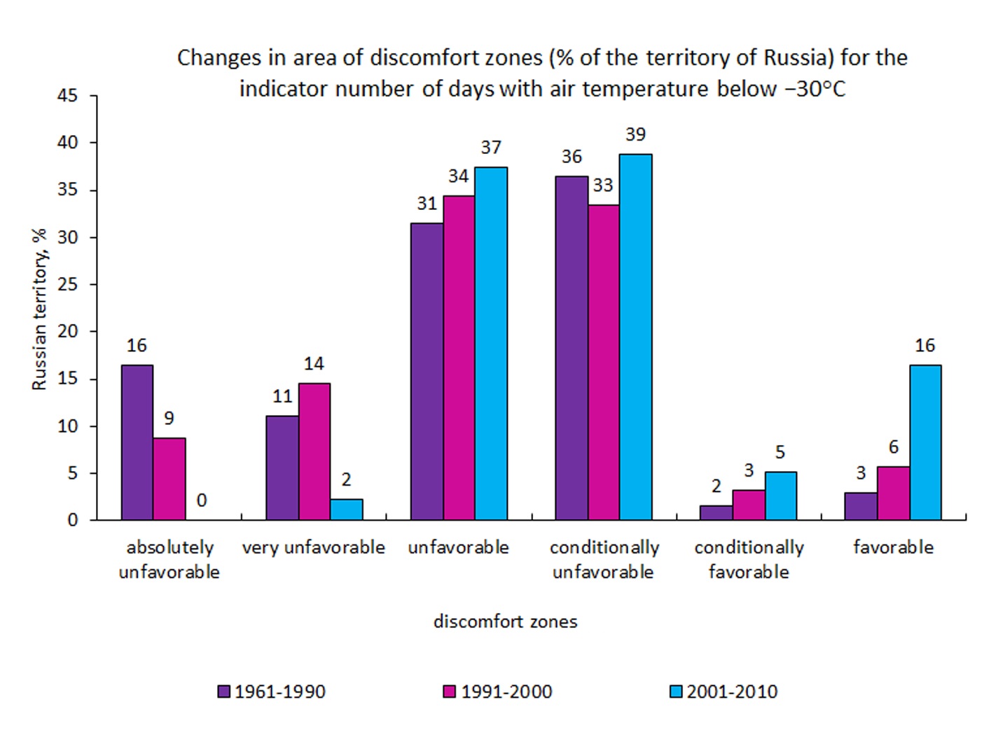
- The changes in the characteristics of cold waves in Russia from 1961 to 2010 were estimated.
- In winter, most of the Russian territory is experiencing a decrease in cold waves and an increase in minimum temperatures.
- At the beginning of the 21st century an area of increasing cold waves and decreasing of temperature appeared in the south of Siberia.
- There is a reduction in the number of days with an air temperature below −30 °С.
- The areas with absolutely unfavorable conditions for this parameter (in the North of Yakutia) disappeared at the beginning of the 21st century.
37-46 965
Abstract
The changes in the quantity, intensity and duration of cold waves in Russia in winter (December– February) for different periods from 1961 to 2010 were estimated. To determine the cold waves, the threshold values corresponding to 5 percentiles of the minimum daily temperature distribution are considered. It is established that in the winter period since 1990s on the most part of the territory of Russia there was a decrease in the number of cold waves and an increase in minimum temperatures. It was found that since 1990s in winter most of Russia’s territory was experienced a decrease in cold waves and an increase in minimum temperatures. But at the beginning of the 21st century these tendencies are weakening, and in the south of Western and Eastern Siberia a vast area appears where an increase in cold waves and a decrease in the minimum temperature are observed. Analysis of cold waves with temperatures below –30 °C showed the disappearance in the beginning of the 21st century the area with absolutely unfavorable climatic conditions in north of Yakutia, the improvement of the conditions up to favorable practically in the entire European territory of Russia and in south of the Far East.
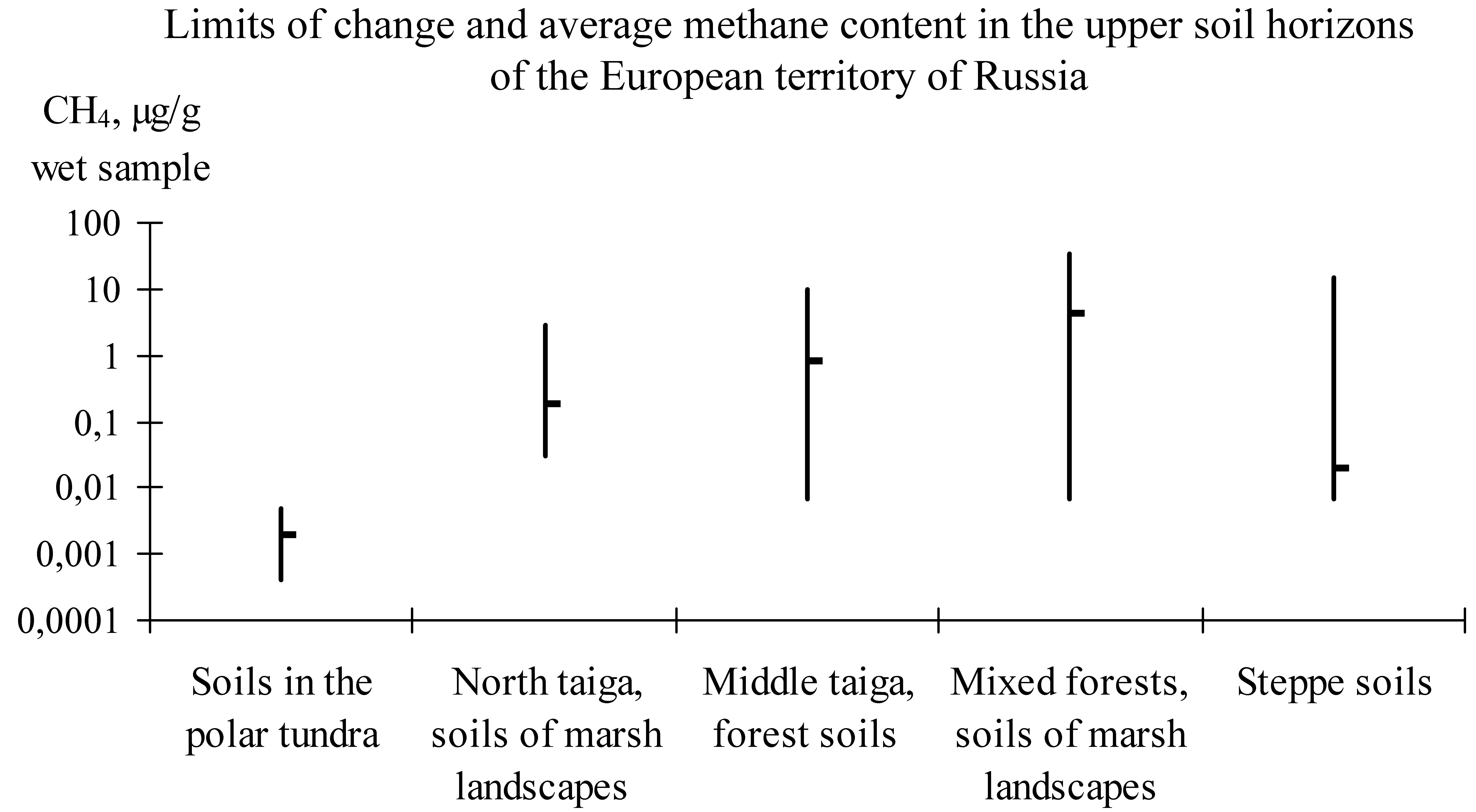
- Dry soils of tundra, taiga-forest, forest-steppe and steppe zones are characterized by low methane content.
- High concentrations of methane are characteristics of soils in wetlands and peat bogs.
- The concentration of methane in soils increases in a range of polar tundra → steppe → taiga → mixed forests.
- In dry and temporarily flooded soils, the concentration of methane down the vertical profile decreases.
- In peat deposits methane concentration increases significantly with depth.
47-55 1222
Abstract
The authors compiled and analyzed experimental data on the distribution of methane content in the soils of the lower Don steppe province (the south of Rostov oblast) and the subzone of typical (average) taiga (Karelia), forest-bog landscapes of Arkhangelsk, Pskov and Moscow oblasts. The data from the literature were also involved. Investigations revealed relatively low concentrations of methane (average of 0.18 µg/g of sample) in drained soils of tundra, taiga forest and steppe zones, and transition zones between forest and steppe, with a trend of increasing its amount from steppe zone to taiga with increasing soil moisture. Higher concentrations of methane (1–2 orders of magnitude higher) are typical for soils of waterlogged sites and peat deposits of bogs. The distribution along the vertical profile of methane in dry and temporarily flooded soils is characterized by a reduction of its concentrations from the surface to the lower horizons, while in peat deposits of bogs, the concentration of gas, by contrast, increases significantly with depth.
- The changes in the taxonomic specificity of clavarioid fungi are investigated on a transect from the tropics to the Arctic.
- Peaks of species richness are revealed in the latitude range from 50 to 60° N.
- The richest localities correspond to average annual temperatures of 1.1–4.5 °C.
- The distribution of fungi from north to south does not correspond to the ‘classical’ latitudinal gradient of diversity.
56-66 780
Abstract
Changes in taxonomic, morphological and substrate specificity of distribution of clavarioid fungi were studied at the Oman-Ural longitudinal transect covered over 6300 km from 20° to 80° northern latitude, along 58° eastern longitude. The works were carried out in two scales. First of scale is cells by 100000 km2 inside 12 latitudinal zones, each by 5° latitude, from the tropical deserts of Arabic Peninsula to the Arctic deserts of Novaya Zemlya Islands. Second scale is 50 localities, by 100 km2 area, situated inside 12 latitudinal cells (as in previous scale). For both scales peaks of species richness of fungi in the close ranges of latitudes, from 50 to 60° N latitude for cells in taiga and south-taiga forests, and 50–65° N latitude, are established. The number of species is reduced to almost zero with decreasing latitude. Such results indicate that the distribution of clavarioid fungi from North to South does not correspond to the “classical” latitudinal gradient of diversity. The number of species in the cells of the Arctic and tropical deserts is similar, and the mean number of species in the localities situated in the tropical deserts is lower than in the Arctic counterparts. The richest localities correspond to cells with average annual temperatures from +1.1 to +4.5 °C. The share of species with small and unbranched fruitbodies positively correlated with latitude, as well as the share of species of saprotrofic grassinhabited taxons. The negative correlation is established for leaves-inhabited taxons, and the share of ground species is relatively constant throughout the entire transect. The share of widespread species, for both scales, is maximal at the desert “ends” of transect, whereas is minimal in the middle latitudes, characterized by the highest number of species. This distribution of the microbiota reflects the bioclimatic specificity of transect: a wide spreading of cryo- and arid deserts, and steppes, in which there are no specific species. The distribution of fungi in a greater degree demonstrates no pattern of changes in diversity with latitude, but the rule of limiting under extreme conditions, which is characterized by a decrease in species richness with increasing pessimal conditions.
Evolution of Natural System
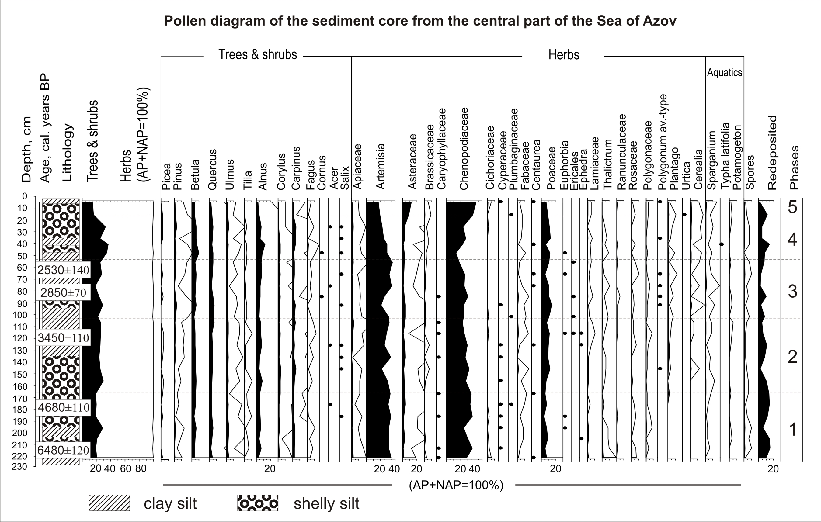
- Pollen analysis of the Holocene deposits of the Sea of Azov detailed the palaeoreconstruction of the region.
- The subrecent pollen spectra of the Sea of Azov are consistent with the surrounding plant communities.
- Steppe communities were widespread as a zonal type of vegetation during the Middle and Late Holocene in the Sea of Azov region.
- Five humid phases influenced the vegetation of the Sea of Azov region during the last 6500 calendar years.
67-78 996
Abstract
The article presents the results of the pollen analysis of the marine sediments of the Azov Sea. Conducted research of subrecent pollen spectra of surface sediment layer is allowed to form an idea of the character of vegetation cover of the coast. The composition and ratio of the main spectrum components agree well with the structure of the surrounding steppe communities, which indicates the prospectivity of the method for regional paleoreconstructions. According to the obtained radiocarbon data, the studied marine sediments were formed during the last 6500 calendar years BP. In the pollen spectra of most columns, there is a high content of pollen of herbaceous plants (80% on average). The group of grasses is dominated by pollen of Chenopodiaceae, Artemisia and Poaceae, in addition, there is a permanent presence of pollen grains of indicative species of dry steppe communities (Ephedra, Plumbaginaceae). However, vegetation cover and climate did not remain constant. A set of phases had been revealed for the last 6500 calendar years BP, namely, 6200–5700, 5500–4000, 3200–2500, 1800–1500, and 650–150 calendar years ago BP, characterized by a significant increase in the amount of pollen of tree species (up to 40%). During these phases, probably, there was the expansion of the area occupied by the forest vegetation in valleys of large rivers under more humid climatic conditions.
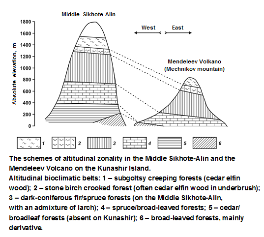
- The empirical-statistical models of the insular-arc stage of continental biosphere formation in the Northwestern Pacific were developed by the example of the active Mendeleev Volcano on the Kunashir Island (the South Kuril Ridge).
- The study showed the simultaneous reduction and compression (compared to the continent) of the entire spectrum of altitudinal zonality, which almost completely (from the forest belts to the subgoltsy belt) fit within the low-mountain layer of macrorelief.
- Direct subordination of phytobiota to vertical hydrothermal gradients forms a system of future altitudinal zonality of the continent already within a framework of low-mountain island-arc landscape.
- The productivity of the forest communities of insular Neo-Pacific in the south of the boreal belt is aimed mainly at the production of green biomass. It significantly accelerates the biological cycle and contributes to the survival of forest ecosystems under unfavorable conditions of ‘cold’ oceanicity.
79-90 931
Abstract
The causal mechanisms of the known geographical phenomenon of insular extratropical Neo-Pacific, i.e., the general descent of the boundaries of altitudinal bioclimatic zones and the southward shift of natural zones on islands compared to the neighboring continents, are discussed. The phenomenal feature of bioclimatic system at the stage of insular landscape formation is the direct subordination of phytobiota to vertical hydrothermal gradients. All the above is conditioned by the domination of transpiration part in thermal balance and ensures the survival of insular ecosystems of the boreal Neo-Pacific under unfavorable conditions of cold oceanicity. It is shown that new types of ecological systems of South Kuril Islands arose in the early Pleistocene, when the cover of the wet taiga forests with ancient (Eopleistocene) well-developed soil had been formed that allows us to consider this period the beginning of the evolutionary processes in the vegetation of these islands.
Natural Recourse Use and Geoecology
91-104 919
Abstract
The integrated geochemical researches of the natural-technogenic landscapes have conducted in the area of development of iron ore (Kursk oblast). The levels of soil, surface waters and bottom deposits of rivers pollution by heavy metals in the zones of influence of industrial facilities of Mikhailovsky mining and processing plant (MPP), including the territory of the city of Zheleznogorsk, have revealed. Soils of trans-accumulative landscapes, bottom deposits and waters of aquatic landscapes of the Pesochnaya, Chern, Rechitsa rivers have undergone the greatest technogenic changes. The content of Co, Ni, Pb, Zn in the soils is minimal, the content of Cu, Mn and Cr in some cases is equal to weak and medium levels of pollution. Tailings pond, quarry, dumps and municipal waste water lead to higher concentrations of heavy metals (Zn, Cu, Cr, Pb) in waters and bottom deposits of rivers. In aquatic landscape of rivers, there is a high content of soluble forms of Fe, which exceeds of maximum permissible concentrations for fishery objects in dozens of times, that is partly a geochemical feature of landscape complexes and surface watercourses of Zheleznogorsk industrial area.
View of a Geographer
105-116 1300
Abstract
Humanities appears now in the “endowed” human being significant and meaningful knowledge as the appropriate meaning of the content of reality. The embodiment of the world picture occurs in multivalued association of signs, symbols, representations and images, where the geography are the only “embedded” in this kind of quickly current processes. Nature was never to humans, it always exists “in itself” and “for itself”, and the man validly “read” and convey its meaning turns out to be possible discourse, while its understanding borders their own limitations of knowledge. In this paper the author’s position are considering via appropriate mapping and interpretation of the opposing “semantic poles” – a wilderness and cultural landscape. In contrast, dichotomous theoretical manifestation of this kind concluded the transcendental meaning of sensory associations (imagery) and rational (logical) cognitive styles of geographical thinking. The concept of the existence the wilderness continuum demonstrates the existing still areas of traditional nature use of indigenous peoples of the Asian part of Russia and those, which modified by anthropogenic development within territory of Siberia.
Surveys and reviews
- In 2017 there were 38 acting dissertation councils in 12 geographical specialties in Russia.
- Analysis of defences in recent years showed a decrease in the number of defenses of dissertations, which is typical for many branches of science.
- Among all the scientific branches the defences in geography are less than 0.6–0.8% of the total number.
- The maximum number of defences belongs to socio-economic geography, physical geography and geoecology.
117-128 691
Abstract
The article is devoted to the analysis of the structure and dynamics of PhD and doctoral thesis defenses in geographical sciences in 2010s. The modern nomenclature of specialties is considered; the number of councils on specialties awarding scientific degrees in geographical sciences is estimated. The current network of dissertation councils is analyzed and the distribution of councils by organizations and their types, by the set of specialties available in councils is shown. Purely geographical councils awarding academic degrees only in geographical sciences (monospecialized; having two or three specialties), and mixed dissertation councils, which award academic degrees in different sciences, are distinguished. The dynamics of defenses is considered in two sections: the place of geography among all fields of science and distribution of defenses among the geographical specialties. Specialties and dissertation councils with the largest and the smallest number of thesis defenses are singled out. The maximum number of defenses falls on the following specialties: economic geography, geoecology (geographical sciences) and physical geography; among the five leading dissertation councils by the number of defenses there are three councils at the Lomonosov Moscow State University.
- Geomorphology of urban areas is a new scientific subdiscipline, created in the 1990s in the structure of anthropogenic geomorphology.
- Relief of urban territory is a combination of natural, technogenic and architectural forms that creates specific geomorphologic conditions as a special type of polygenetic surface.
- The collective monograph Geomorphology of urban areas: constructive ideas, edited by E.A. Likhacheva and S.I. Bolysov (2017), is devoted to the study of the geomorphology of Moscow city and Moscow agglomeration.
129-130 590
In Memoriam
ISSN 2587-5566 (Print)
ISSN 2658-6975 (Online)
ISSN 2658-6975 (Online)


