

From the Editor-in-Chief
Theory and Social Functions of Geography
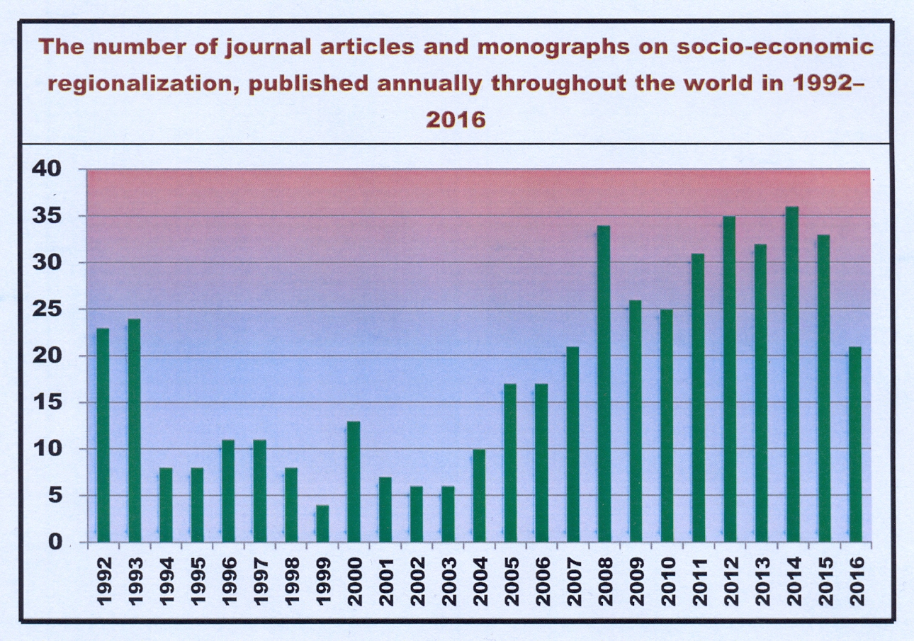
- Between 1992 and 2016 most of scientific publications on regionalization (zoning) were publishing at first in foreign journals and books, and later in Russian ones.
- Scientific interest in human geography shifted from economic to non-economic regionalization.
- Interest increased in cultural-geographical regionalization and decreased in sectoral socio-economic one.
- The peak of interest in cultural-geographical regionalization passed in 2012–2016.
- In the era of big data, at least seven new kinds of regionalization will appear.
The article presents the results of the first generalization of domestic and foreign works (journal articles and monographs) on the socioeconomic regionalization, published in 1992–2016. The purpose of generalization is to identify development trends for groups of types of regionalization and their extrapolation to 2017– 2026. Distribution of publications by five groups (integral economic, sectoral socioeconomic, political-administrative, recreation-geographical, and cultural-geographical regionalization) is analyzed. It was found that in the post-Soviet period in the world there has been a decline in the relative importance of the first three groups and the increase for the last two groups. For Russian publications, a significant decline in the importance of an integral economic regionalization is recorded, as well as not such a big drop of the second and the third groups on the background of a rapid growth of the fourth and fifth groups. The extrapolation of global trends to 2017–2026 allowed assessing the impact of the future on current estimates: the first three groups of regionalization became to be assessed less pessimistic, and the last two groups are less optimistic. It is shown that in the future new kinds of socioeconomic regionalization based on the “big data” may be formed out of identified trends.
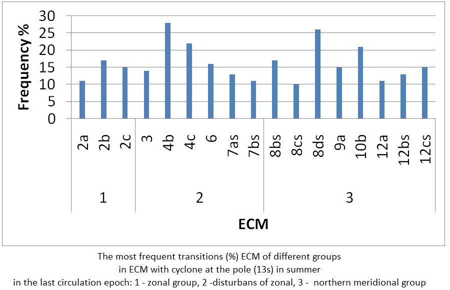
- The frequency of transitions of elementary circulation mechanisms (ECM) to each other from 1899 to 2016 was analysed on the basis of the classification by B.L. Dzerdzeevskii.
- Differences in reiteration of ECM for three circulation epochs: meridional northern (1899–1915), zonal (1916–1956), meridional southern (1957–2016).
- The frequency of ‘random’ transitions, with low frequency, has increased. An increase in the volatility of atmospheric processes over the past decades.
- More than two-fold reduction of share of such ECM transitions, in which the elements of the previous process were preserved, is associated with a present increase in the frequency of extreme weather and climate phenomena.
The oscillations of the atmospheric circulation of the Northern Hemisphere in the period 1899–2016 according to the classification of B.L. Dzerdzeevskii, V.M. Kurganskaya, Z.M. Vitvitskaya were studied in the paper. The reiteration of switches of the elementary circulation mechanisms (ECMs) into each other during the study period was analyzed and the differences in the alternation of the ECMs in the three circulation epochs were determined. During the study the most common, as well as not occurring switches were identified. In addition, it was found that in the transition from the meridional epoch to the zonal there was not only a general decrease in the duration of meridional processes, but also changes in the structure of the meridional group were observed. Reduction of the reiteration of the ECMs with three and two far removed from each other blocking processes (on Siberia and America or on Europe and America) was accompanied by the growth of the reiteration of the ECMs with two closely spaced blocking processes (for example, on the Atlantic and Europe). The results of the analysis show the increase in the instability of atmospheric processes during the second half of the 20th century, and especially in the last 19 years. The significant decrease in the share of the ECM switches with blocking processes with preservation of the previous process elements more than twice during the period from the first to the third circulating epoch also indicates an increase in the instability of the atmosphere, which leads to an increase in the reiteration of extreme weather events in Russia.
Territorial Organization of Society
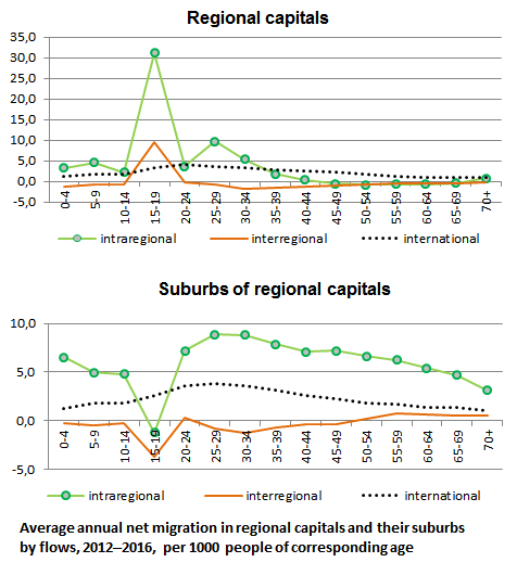
- Regional capitals and their suburbs are stable points of population growth in Russia. This growth is primarily provided by intraregional migration.
- In 2012–2016 suburbs were ahead of regional capitals in terms of migration growth rates. That is a sign of suburbanization.
- Centres attract young people looking for higher education opportunities. Suburbs attract people aged 30 years and older.
Capital cities of the Russian regions and their suburbs demonstrate stability in terms of population increase. In this paper we define suburban areas for 72 regional centers of Russia (excluding Moscow oblast, Leningrad oblast and a set of other federal subjects) based on the proximity to the regional center. In our analysis we used net migration increase/decrease for 2012–2016 calculated on the basis of Municipal Formations’ Indicators database, which also 1) distinguishing between intraregional, interregional and international migration and 2) distributing migration data across 5-year age groups. The analysis shows that net migration patterns of large cities and their suburbs have no regional peculiarities: regional centers and their suburban areas attractive for migrants dominate in all parts of the country reflecting the centripetal trend of migration. Suburbs from regional capitals on average are differed not only more intensive migration increase, but also the peculiarities of its structure. While centers attract mostly young people, primarily at the age of enrolling into a university, suburbs are more popular destinations for families with children, middle-aged people and the elderly.
Natural Processes and Dynamics of Geosystems
Evaluation of soil organic carbon (SOC) storage in 11800 km2 area of tundra and forest-tundra in Usa River basin was carried out using multiple regression with account of soil taxa and influence of climate and topography. The model explained 84% of spatial variability in SOC storage. Negative relations were found between SOC and climatic norms of June precipitation, as well as elevation; causes of these relations are discussed. Based on the model, a gridded map of SOC storages was calculated at resolution 300 m. In addition, a grid of SOC storages was calculated using spatially uniform “reference” values that are averages by observation points for soil taxa. An average of SOC storages by the model is 21.6 kgC/m2 , while it is 32.0 kgC/m2 when the “reference” values were used. Corrected “reference” values calculated from the model were suggested that are 1.5 times lower than those obtained from observation points. It was shown that average deviations of SOC storages from corrected “reference” values, which reflect influence of climate and topography, are 5.85 kgC/m2 . When climate and topography are taken into account in addition to soil taxa, this provides more correct evaluation of SOC than frequently used “reference” values for soil taxa. It is shown that the distinctions are not small.
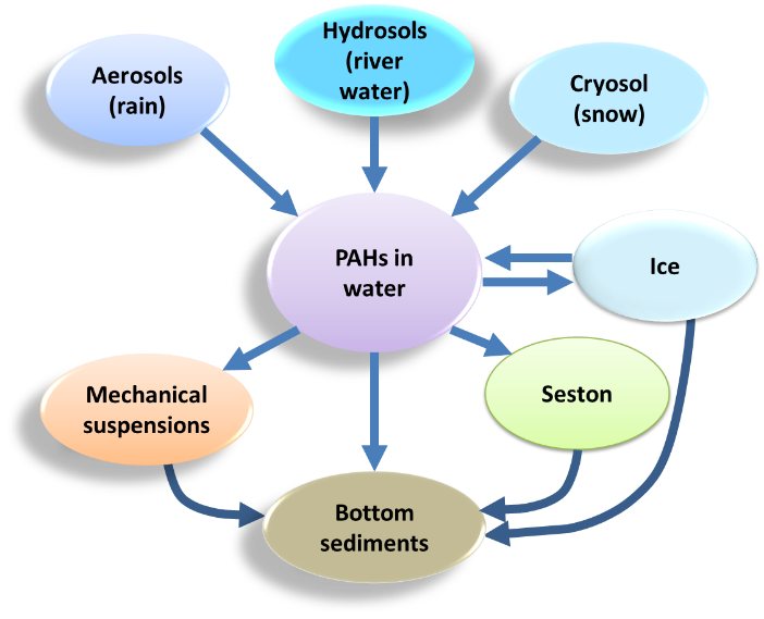
- At the phase transitions the polycyclic aromatic hydrocarbons (PAH) are efficient indicator of the intensity of matter flows.
- The PAH transition is maximal at the barriers with participation of living matter (water–seston, concentration coefficient CC > 64000), followed by the water–bottom sediments barriers (CC up to 3500). The minimal CC is at the snow–ice barrier (1.2).
- Analysis of the structural bonds in the aquatic system based on the PAH data shows significant differences between the zones of the marginal filter (according to the concept by A.P. Lisitsyn).
The processes of phase transitions of polycyclic aromatic hydrocarbons (PAHs) at geochemical barriers in the components of the aquatic system of the marginal filter of the Severnaya Dvina River are studied based on experimental data. The analysis of the behavior of the most common PAHs in the region is carried out. The PAHs can be considered as reliable indicators of the formation and interaction of components of the aquatic system within the marginal filter, taking into account the development of anthropogenic processes. A phe nomenological model of migration and formation of associations of the most persistent compounds in the range of geochemical barriers is developed. The predominant possibility of migration of PAHs on the suspended material, including biota, is shown. The specificity of the chemical structures of the PAHs determines the characteristics of the transition of PAHs in different zones of the marginal filter in the interaction in systems “snow–ice”, “ice–water”, “water–suspensions”, “water–bottom sediments”. The relationship between important physical and chemical properties of PAHs as factors of their migration activity and real distributions of activity of migration and transformation of complexes of PAHs in different zones of the marginal filter is evaluated. Active and passive PAHs from the point of view of their migration and accumulation in the components of aquatic systems are identified. The classification of PAHs according to the conditions of their migration through barriers taking into account their physicochemical properties is carried out.

- The restoration of vegetation is impeded by the movement of the pyroclastic cover, the lack of moisture, the absence of sources of plant diaspores.
- The initial stages of primary succession are much longer in the western part of the caldera than as scholars could suppose 25 years ago.
- The first plants that appear on the pumice desert are low bushes and dwarf shrubs, similar to pioneering species of perennial grass in their structural and functional characteristics.
- Most favourable microclimate and edaphic conditions exist in the system of linear hollows on the southern slope of the Shtyubel cone.
The flora and vegetation of the hard-to-reach Ksudach caldera complex (Kamchatka) was first studied by S.Yu. Grishin with colleagues in the early 90s of the 20th century. After 25 years, complex routing studies were completed, supplemented by interpretation of aerial photographs. It was established that the formation of vegetation within the caldera Ksudach (Kamchatka) after 109 years after the catastrophic eruption of the Shtubel cone in March 1907 is extremely uneven. The slowest recovery is in the territories where the layer of fallen tephra is maximal, the active movement of the pyroclastic cover continues under the influence of reliefforming processes – erosion, deflation, lahars and landslides and landslips forming, etc., there is a moisture deficit and there are no nearby sources of primordia plant. One of these sites is the western part of the caldera, represented by pumice desert, sparsely populated pioneer plant species and some shrubs, which still passes the initial stage of primary succession. In the rest of the inner part of the caldera Ksudach and slopes of the Shtubel cone tested active demutational processes that mark continuous step primary succession to form vegetation folded various embodiments of integrated meadow and mountain-tundra shrub communities with inclusion bush forms Alnus fruticosa and, to a lesser extent, Betula ermanii. In these processes Pinus pumila does not play a significant role.
Evolution of Natural System

- Recent climate changes at the Polar Urals enhance the risk of late spring frosts.
- During warm climatic periods the frequency of frost damages located in earlywood increases.
- Early start of the growing season and low snow depth in May contribute to rise in frost ring formation in earlywood.
Frequency of recurrence, intensity and spatio-temporal distribution of frost damage in larch and spruce growing on the same southwest exposed slope at the upper tree-line and at the bottom of the mountain valley in the Polar Ural Mountains were studied with aim to reveal the dynamics of their formation in different climatic periods over the last 100 years. At the upper tree-line damages form more often in larch than in spruce, but at the bottom of the valley, on the contrary, damages form two-three times less frequently in larch than in spruce in the same climatic periods. The high frequency of damage formation in early wood is confined with warm climatic periods with early start of vegetation and low May snow depth. The most extreme years have been identified, when a large number of trees are damaged. The difference in frequency of frost damage formation with West Siberian has shown. Risk of a damage of coniferous trees by late spring frosts due to recent climate changes in the Polar Urals is increased.
Natural Recourse Use and Geoecology

- Natural radionuclide 232Th has a potential to be implemented as tracer in survey conducted within territories with radioactive fields.
- The pattern of 232Th distribution in Hackman canyon (Khibiny Mountains) is caused by range of geologic and geographic factors.
- 232Th distribution correlates with sediment grain-size composition.
The potential of application of 232Th daughter radionuclides as tracer in lithodinamic and geomorphic investigations was explored. It was analyzed geochemical particularities of this radionuclide, its occurrence in rocks and sediments and ways of migration. A series of samples of sediments and river waters was collected within the Hackman canyon in the Khibiny Massif (the Kola Peninsula) and analyzed by a semiconductor gamma spectrometer to recognize activity of 232Th daughter radionuclides: 228Ac and 212Pb. In the 1930-s there was a lovchorrite mining within Hackman canyon, which tailings were enriched in 232Th. Their material is moved by different natural processes: mudflows, snow-water flows, erosion and complex slope processes. The spatial heterogeneity of radionuclide composition of loose sediments is detected, the analysis of which allowed to identify promising areas of geological-geomorphological studies and environmental risk assessment in the areas of production of radioactive thorium-containing rocks in the mountain conditions of Subarctic and protection of the natural environment.
Regional Geographical Problems
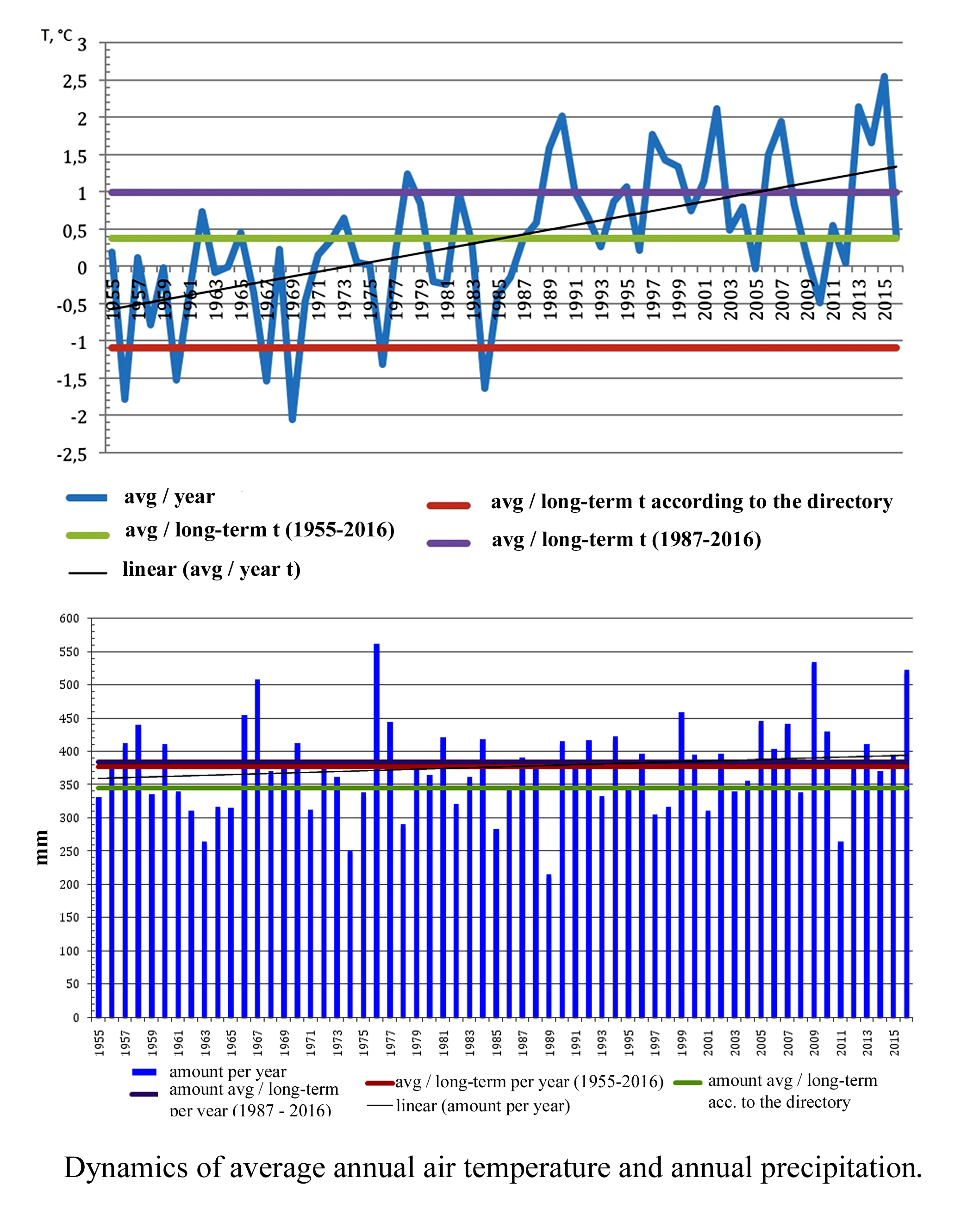
- The cold pole of the Altai is the Chuya depression with average January temperature below −30 °C.
- The weather station Ust-Koksa showed the highest growth of summer precipitation amounts (33 mm).
- We found intra-annual heterogeneity of temperature changes and significant fluctuations in mean winter temperatures (from −23 °C (2009) to −15.7 °C (2015)) in Altai.
The study of the regional manifestations of climate change in mountain areas is of special significance, because it can refine the planetary picture of climate changes. Multiyear meteorological data (60 year period) on high-mountain and mid-mountain intermountain hollows – the Chuya hollow (Southeastern Altai physical and geographical province), Kanskaya, Uimonskaya and Ursulskaya troughs (Central Altai physical and geographical province) are analyzed. It is shown that the most significant changes in air temperature and precipitation occur in the Chuya hollow. Based on linear trends, it is found that the average annual air temperature increased 3°C over 1955–2016. In the Kanskaya, Uimonskaya and Ursulskaya troughs, this value is 1.8, 1.9 and 2.3°C, respectively. However, at the same time there is a tendency to a slight cold snap of the last decade. Substantial changes in precipitation patterns in all studied areas are not revealed, but some differences are found when considering seasonal patterns based on linear trends. So, everywhere increase in summer precipitation is recorded: on 33 mm at the meteorological station Ust-Koksa, 23 mm at the meteorological station Ust-Kan and 12 mm at the meteorological station Kosh-Agach. The amount of winter precipitation is reduced by values from 2 to 10 mm. These values are not statistically significant and are provided to illustrate emerging trends. Despite the increase in summer precipitation, these changes indicate a significant trend of increasing aridity of the territory, since the observed increase in air temperatures is not accompanied by a corresponding increase in precipitation.
Geoinformation Systems and Mappings
The Unified State Register of soil resources of Russia (with Russian abbreviation of EGRPR) is the official innovative information resource of soil of the country. The EGRPR contains complete, unified, digital information of all the soils of the country, their properties and spatial distribution. On the basis of the GIS approach it is shown that the diversity of forest soil is presented by 12 of the 15 soil departments (the highest taxonomic level in the Russian soil classification hierarchy). Two of the missing soil departments (Cyozems and Low-humus-accumulative-carbonate soils) are outside of the forest zone. The third of the missing soil departments (Organogenic) characterizes the peat soils with intensive hydromorphic and anaerobic features unfavorable for the forest growth. The Al-Fe-humus podzols and podburs (216.7 mln ha) are the most extended forest soils in Russia. The texture-differentiated podzolic (173.1 mln ha) soil occupies the second place. The Metamorphic burozems and Brown-taiga soils (164.8 mln ha) take the third place. Different tree species show diverse demand for water and air regime and nutrients availability of the soil. The highest selectivity demonstrates fir and, to a lesser extent, spruce forests. Hardwood forests are more demanding to soil conditions, than deciduous. Shrubs are characterized by wide edaphic and hydrothermal plasticity.
History of Geography
- The book Universal Geography (Geographia Generalis) by the great scholar of the 17th century Bernhardus Varenius was published in Russian in 1718.
- Translation of the book and its publication in Moscow became an important step in the transfer of scientific knowledge from Europe to Russia.
- Exclusively thanks to the efforts of Peter the Great and his associate Ya.V. Bryus (J. Bruce) Varenius’ work became available to Russian reader.
“Universal Geography” of Bernhardus Varenius (1622–1650) is a classic work on geography. Isaac Newton taught a course in geography at Cambridge University on the book of Varenius and twice in his redaction and with additions published it in England. The wide scientific resonance and special popularity of “Universal Geography” in England defined Peter The Great’s decision according to the authoritative recommendation of J.V. Bruce to choice this composition as a textbook. The publication in 1718 of “Universal geography” of B. Varenius had played an important role in the development of geographical knowledge and teaching geography in Russia.
View of a Geographer
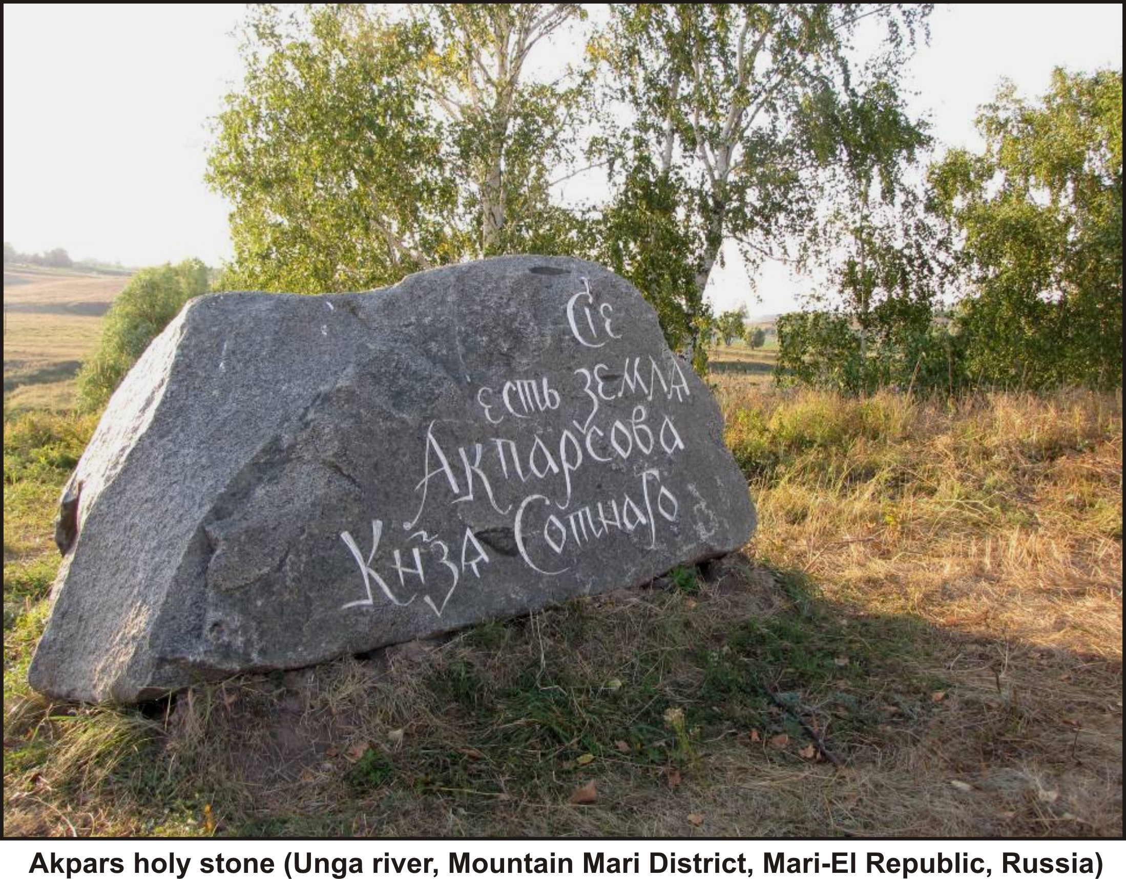
- Sacral landscape manifests itself in all components of the traditional rural ethnocultural landscape, particularly clearly in sacrosanct worship places and traditional land management.
- The questionnaire survey of Russian and Highland Mari villages has revealed both similarities and remarkable differences in ecological styles of thinking of these neighbouring folks.
- The archaic and traditional constituents of the sacral landscapes of the folks have a strong impact on their style of ethnic thinking.
- The sacral landscapes play a decisive role in the origin, evolution, and stability of the ethnic mentality and traditional style of land management.
- An ecological ethics should be largely based on rational traditional land management and on environment-protecting ethnic mentality, whose stability is maintained by sacral landscapes.
Specifics of sacral landscapes (SLs) are discussed with reference to the Mari people in the Republic of Mari El. The SL is a multicomponent system penetrating all elements of the traditional rural ethnic-cultural landscape, from habitation and mansion houses to sacral shrines. SLs are determined to most fully manifest themselves in sacral shrines and traditional land management. SLs are demonstrated to be a key component of the ethnical culture of the highland Mari people and have archaic, traditional, and modern aspects. The paper presents results and analysis of the questionnaire survey of Russian and Mari villages and hamlets in the Gornomariiskii District of the Mari El Republic with the application of nonparametrical mathematical statistics. Data on the attitude of neighboring peoples to nature reveals both similarities and significant differences of the ecological thinking of the Russian and Mari people. Nevertheless, these data convincingly demonstrate that the worldviews of the peoples are closely related to the natural environment and provide sound grounds for the conclusion that SLs are an important factor of the origin, evolution, and stability of ethnical thinking and traditional land management. The latter is, according to the authors, the basis of ethnical ecological thinking. The authors arrive at the conclusion that ecological ethics of the present and future should rely, first and foremost, on rational land management, which is based on historically established and verified traditional land management and on traditional ethnic nature-oriented mentality, whose stability and vitality are maintained by sacral cultural landscapes.
Surveys and reviews
Review of the book of Geocultures of the Arctic: methodology of analysis and applied research. Monograph / Zamyatin D.N. and Romanova E.N. (Ed.), Moscow: Kanon+, ROOI Reabilitatsiya, 2007. 504 p. This article reviews the monograph, published by the Laboratory of complex geocultural studies of the Arctic of the Arctic State Institute of Culture and Arts (Yakutsk) and devoted to the study of key factors in the development of an integrated information and cultural space of the North. It presents the results of interdisciplinary, theoretical and methodological and applied research of an international team of scientists. Geocultures of the Arctic are considered in the context of different discourses (philosophical, cultural, cultural and geographical, ethnographic, anthropological, philological, etc.). It was made the attempt of a holistic representation of problems of interaction of cultures and spaces of the circumpolar world, of understanding different sections of the cultural landscape and creation of the three-dimensional pattern of this unique region.
Content of nos. 1–6, 2018.
ISSN 2658-6975 (Online)


