

No 1 (2020)
From the Editor-in-Chief

Theory and Social Functions of Geography
- The analysis of 350 geographical discoveries in the 20th century. Most of them were made during the relatively peaceful periods from 1931 to 1940 and from 1951 to 1960 in the polar regions and the oceans.
- The hierarchy of discoveries is investigated according to the number of requests to the Yandex search engine.
- The role of technical tools and methods used to create a new portrait of the world is traced.
7-19 2321
Abstract
The analysis and synthesis of geographical discoveries on Earth in the XX century. The criteria allowing to reveal the most significant new data on a surface of the Earth influencing development of a civilization, economy and science are defined. The analysis includes about 350 discoveries. The place of the XX century in the system of periodization of geographical discoveries and their dynamics is determined. The most intensive discoveries were made in relatively peaceful years (in 1931–1940 and 1951–1960) in the polar regions and in the world ocean. The contribution to the world treasury of discoveries of employees of the Institute of geography of RAS is specified. They play a decisive role in the identification of regional centers of glaciation in Northern Eurasia, in the discovery of many subglacial morphostructures and lake Vostok in Antarctic, underwater elevations, ridges and troughs in the world ocean, lineaments, etc. Formal parameters – the interest of modern man (the number of requests in the Russian search system Yandex) defined hierarchy of discoveries of the XX century: the archipelago of Severnaya Zemlya in 1913 (132 mln hits); Centers of origin of cultivated plants, 1926–1939 years (103 mln); the origins of the Amazon river, 1996 (91 mln); the ring structure of the Earth, 1970 (83 mln); “Black smokers” on the ocean floor, 1977 (68 mln); modern glaciation of Northern Eurasia, 1929–1958 years (68 mln); Gamburtsev mountains in Antarctica, 1958 (65 mln); Chersky ridge in the NorthEast of Siberia, 1926 (63 mln), sources of the Nile river, 1937 (54 mln); lake Vostok in Antarctica, 1955–1996 (53 mln), etc. It is shown that the geographers of the ХХ century received the baton from the past centuries. Changing and studied in detail by field and remote methods, the planet in the XXI century becomes an arena for the study of the modern, “anthropocene” portrait of the world.
Territorial Organization of Society
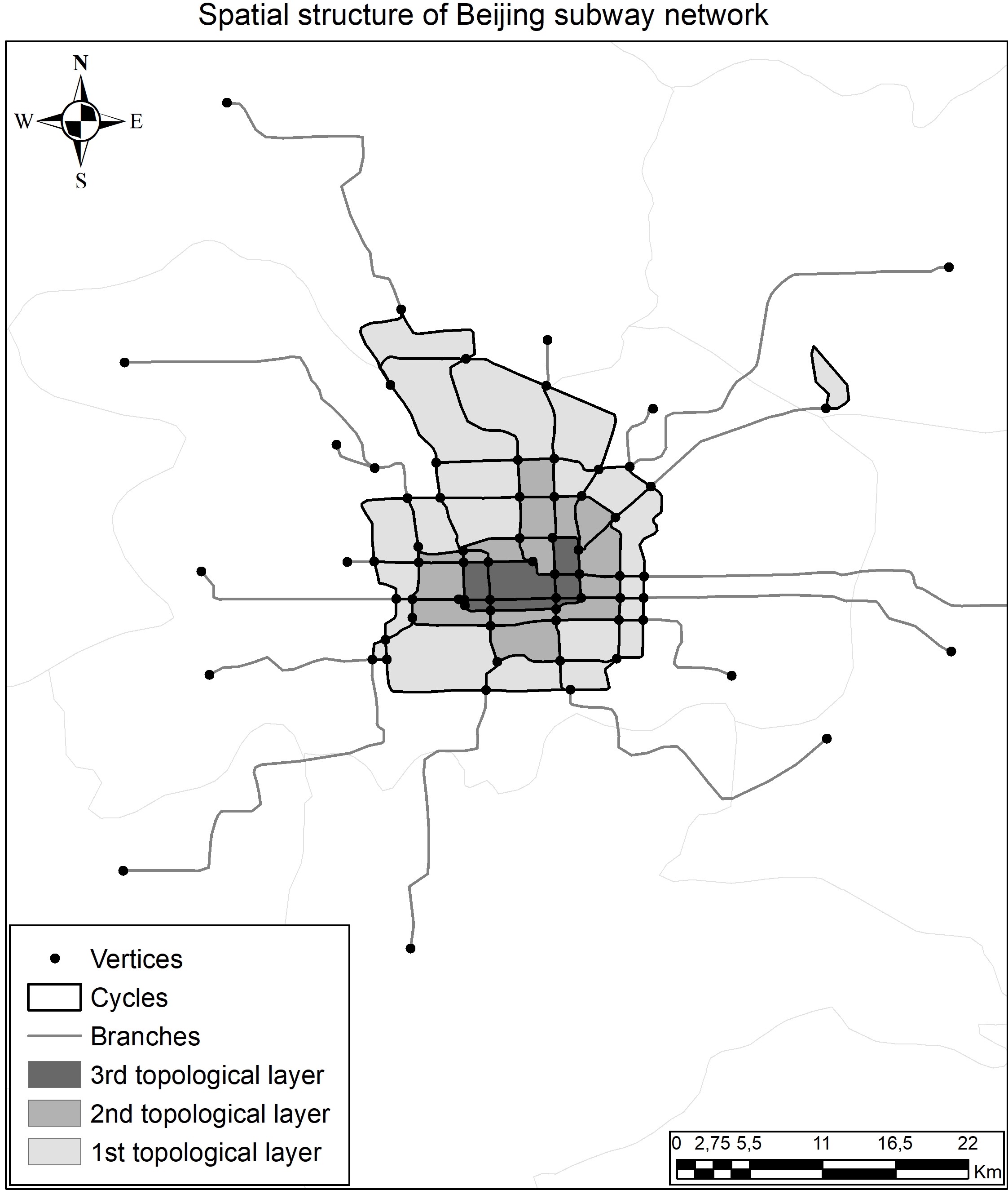
- Networks with a lot of cycles have the most developed topological layers, while in networks with a small number of cycles, the structure of layers is deformed.
- Overall cyclic growth of network doesn’t lead to an increase in the level of connectivity.
- Differences in spatial structures allow us to distinguish several types of subway networks.
20-26 804
Abstract
Subway systems play a very important role in development of modern cities. Their spatial structure changes and transforms as system grows. Subway networks are key components in evolution of cities’ spatial structure. It must be mentioned that current design of the most world’s subways doesn’t match with their original plan. In this article we make a comparative analysis of spatial structures’ evolution for world’s biggest subway networks in: Shanghai, Beijing, Tokyo, Seoul, London, and New York. Analysis is based on comparing the quantitative and qualitative properties of networks. Methodology used in this research is based on the works of K. Kansky and S. Tarkhov. The key component of the research is transforming of network to graph using GIS-technologies. Networks were compared on several topological indicators. The results let us find the key moments of networks’ spatial structures development and divide them into several groups.
- Barrier function of urban habitat represents the degree the city disintegrated into the areas separated by weakly permeable borders.
- There are three main types of city barriers, namely car roads, railroads, and water barriers.
- City barriers determine two key directions of city development that are magistralization and polarization.
- City barriers differentiate city space into functional zones, cultural and administrative districts.
27-36 1300
Abstract
The article is devoted to the analysis of city boundaries-barriers in Moscow. City barrier is considered as one of the types of boundary between city nodal areas. Such boundary is rigid, clear, and quasilinear and it exists for a long time (decades or more). The barrier function of the urban environment is the degree of city disintegration into relatively loosely connected areas with internal integrity. There are three types of urban barriers’ genesis – automobile, rail, and water. Military, forested, industrial and fenced private areas are not considered because they do not divide city regions (social, economic, political etc.), but only separate selected areas from the urban environment (they are independent regions). There are barriers with maximum and minimum permeability of borders for each city. The boundaries’ permeability in this case refers to the possibility and degree of trespassing the barrier. The author names the city barrier with the maximum permeability “barrierstandard”, and the barrier with minimum permeability “barrier-filter”. Comparison of “barrier-standard” and “barrier-filter” demonstrates territorial differences within the city. Comparison of different types of barriers with the “barrier-standard” and the “barrier-filter” allows to measure representative permeability value in comparison with maximum and minimum values.
Natural Processes and Dynamics of Geosystems
- The spring slope runoff (SSR) is one of the most important hydrological phenomena on the territory of the Russian Plain.
- The value of SSR was calculated for the years of different dryness in the southern part of the forest, forest-steppe and steppe zones of the Russian Plain.
- In the modern (since 1981) period, there has been a significant decrease in SSR in all natural zones of the Russian Plain.
- The SSR reduction positively affects soil moisture reserves, but at the same time, it leads to the decrease of the river runoff resources.
37-46 780
Abstract
The important hydrological and hydro-ecological role of slope runoff, especially in spring (SSR), is shown. The data of 28 water balance stations on the SSR value on the territory of the Russian Plain in the years of different water flow are summarized. The hydrological role of autumn ploughing in the forest-steppe and steppe zones is shown. It leads to SSR decrease on the fields of autumn ploughing in comparison with the SSR on the fields not plowed in autumn, and most significantly in high-water and average years. The exception is the driest years, when there is no surface slope runoff on all lands. Two periods are considered – from the 1920s to 1980 and from 1981 to the present time. They are characterized by different climate features and anthropogenic impact. It is revealed that the SSR in the second period has reduced dramatically (by several times), mainly as a result of climate change, which has both positive and negative consequences.
- Changes in the synchronization regimes of climatic processes are a sign of a system transition to another state.
- Climate classification by the coherence of temperature fluctuations is an objective way to study the transformation of climate structures.
- In periods of different directions of global trends, the regional structure of the consistency of temperature changes is different.
- The territories most sensitive to global climatic trends have been identified.
47-55 675
Abstract
The selection of informative criteria and objective classification methods is the current task of climatology. In this paper we present the results of the clustering algorithm of climate. The temperature signals are classified by the degree of similarity of the phase modulation characteristics. Different time periods were considered. They correspond to the main trends in the global temperature dynamics. Such an approach may be a variant of the objective dynamic classification of the Northern Hemisphere climate. Data from 818 meteorological stations were used. The transformation of the system and changes in the degree of temperature dynamics’ consistency at different intervals of years are revealed. This made it possible to identify the most sensitive areas of the Northern Hemisphere. In these areas the stations changed its structural affiliation depending on global trends. With increasing global temperature, the structure of the regional fields is changing. Coherence of temperature fluctuations varies. There is a transition of many stations of more northern classes to more southern ones. The most sensitive to global climate trends are the territories of Fennoscandia and Central Europe, Greenland, the Russian Arctic and Subarctic, Florida Peninsula, and stations located in a mountainous terrain Eurasian areas and areas of influence of basic centers of atmospheric action.
- To understand the geographical anomaly of steppe communities in the forest zone, it is important to compare their biotopes.
- The hydrothermal regime of the steppe and background biotopes of the reserve was compared.
- Annual temperature variation and synchronous spectra of soil moisture at different periods of vegetation with different combinations of climatic factors are presented.
- The steppe biotope is the driest and warmest in the reserve and depends only on precipitation.
- Steppes formed under conditions of a ‘temperature trap’ and a lack of moisture during critical periods of vegetation.
56-68 802
Abstract
The growth of steppe plant species (so called “Oka flora” in the Prioksko-Terrasny Reserve) in the forest zone is a botanical phenomenon. To understand the mechanisms of such biogeographic anomalies’ formation, comparative studies of steppe communities’ habitats and zonal forest vegetation are important. In the article, for the first time on the original experimental material, an assessment of the humidity and hydrothermal regime of steppe communities’ habitat, its difference from biotopes of neighboring meadow and forest ecosystems, within the alien zone has been carried out. It is shown that the biotope of steppe vegetation has distinct differences from biotopes of other vegetation types of the reserve. The humid regime of meadow-steppe associations and the neighboring pine forest during the growing season is determined only by atmospheric precipitation, in contrast to the biotopes of other types of vegetation, in which the influence of upper water is noticeable. The most significant influence of the upper water was observed on the middle terraces of the Oka River (Rodnikovaya Polyana). Steppe vegetation of the Doly tract is formed in conditions of a “temperature trap” and lack of moisture during critical periods of spring and early autumn. The increase in summer temperatures and the duration of the summer period in the Moscow oblast’s southern part, as well as repeated droughts in the second half of summer and early autumn contribute to the preservation and expansion of the steppe area in the south of Moscow oblast.
Natural Recourse Use and Geoecology
- Expert criterion system provides a scientific rationale for decision making even in the face of a lack of factual data.
- The natural instability of geosystems and their elements makes economic use of Sakhalin and Iturup islands’ coasts difficult.
- The attractiveness and uniqueness of the coastal landscapes, as well as the ability of their recreational use while preserving geoecological value, define the recreational value of the coasts.
- Combination of natural and socio-economic characteristics of Sakhalin and Iturup islands’ coasts does not lead to insoluble inter-sectoral conflicts.
69-79 619
Abstract
The criterion system for a complex estimation of the economic and geoecological state of the coasts, their resistance to possible natural and man-made impacts is presented and tested in the paper on examples of Sakhalin and Iturup islands. This criterion system takes into account both the current state of the seacoasts and their past and forecasted variability. For complex estimation of the coasts’ state by proposed criterion system coastal sections with different geographical characteristics, intensity and types of economic use were selected. The estimation showed that the natural variability of geosystems and their high susceptibility to natural threats create the greatest difficulty for the economic use of selected coast sections. The probability of largescale actions’ carrying out to increase the coastline resilience to natural threats is low. Natural features of coastal landscapes, combined with a relatively low population density and small number of economic sites in the analyzed area, as a rule, do not lead to insoluble inter-industry contradiction. Recommendations about the feasibility of the type of economic use for coast sector are given based on the complex estimation fulfilled.
- Geochemical barriers play a crucial role in the matter and energy flows distribution in marginal filters.
- Geochemical barriers represent an active self-organizing medium, centres of evolution of geochemical systems.
- The most contrasting mass transfer models are based on the data on PAHs migration.
- Insulating properties of geochemical barriers in the aquatic system differ by 5 orders of magnitude.
- Maximum matter flows in aquatic systems come through barriers to living matter and bottom sediments.
80-92 774
Abstract
Carried out the analysis of the behavior of the most common polycyclic aromatic hydrocarbons (PAHs) in the region: anthracene (An), phenanthrene (Phen), naphthalene (Naph), pyrene (Py), fluoranthene (Flu), chrysene (Chr), benzo(a)pyrene (BaP), perylene (Pl). PAHs can be considered as reliable indicators of the formation and interaction of components within the marginal filter, including the development of anthropogenic processes. In the present material a phenomenological model of migration and formation of associations of the most persistent compounds in the range of geochemical barriers was developed. Based on the scheme of PAHs flows in the components of the aquatic system confirmed the predominant of their migration on suspended material, including biota. The specificity of the chemical structures of the PAHs determines the characteristics of the transition of PAHs in different zones of the marginal filter in case of interaction in systems “snow–ice”, “ice–water”, “water–suspensions” (including seston), “water–bottom sediments”. Evaluated the relationship between important physical and chemical properties of PAHs as factors in their migration activity and real distributions of activity migration and transformation of complexes of PAHs in different zones of the marginal filter. Identified active and passive PAHs from the point of view of their migration and accumulation in the components of aquatic systems. Carried out the typization of PAHs according to the conditions of their migration through barriers considering their physicochemical properties.
Regional Geographical Problems
93-102 1067
Abstract
Climatic signal in the linear and radial increment of Scots pine (Pinus sylvestris L.) growing on the Russian Plain and particularly in Kerzhenskiy national reserve (the Republic of Tatarstan) is well examined. It was determined that precipitation is the key factor of the tree growth in the temperate climate. At the same time, changing character of precipitation was revealed on the Russian Plain for the last five decades. It is associated with long-term increase of convective showers and decrease of stratiform precipitation. Therefore, the study’s important task is to examine the relationship between Scots pine increment and the different types of precipitation. The issue examines the relations between linear and radial increment and precipitation of different genesis in three biotope types: moist, fresh and dry. The linear increment shows sensitivity to heavy showers in the beginning of the growing season when a tree strongly depends on soils moisture. All biotope types show a significant positive signal to the convective precipitation except moist biotope which shows a negative signal. It can be explained by water stress and oxygen deficit in the root layer. Stratiform precipitation has significant negative influence on the linear increment. This fact indicates a negative impact of the prolonged moisturizing on the increment of the current year and the quality of the renewal bud in the previous season. Radial tree increment demonstrates a less significant response to precipitation of different genesis. It is characterized by a positive relationship with proportion of heavy rains at the beginning of the current growing season when early wood forms and the second half of the previous year growing season when a more mature wood begins to form.
- The modern degradation of the small rivers such as the decrease in water flow and turning into dry lands is caused by natural forces.
- The decrease of the spring flood and the changes in its genesis destabilize the state of the bodies of water.
- The spring flood is extending in time due to both earlier start and later ending.
- The peaks of the spring floods and summer low water levels are occurring later in the year.
- The seasonal variations in the river water flows become smaller.
103-113 951
Abstract
The article substantiates the methodology of distinction between the Upper and the Middle basins of the Don river. The suggested demarcation line, undefined until now, should coincide with the administrative border of the Voronezh oblast in the south, south-east, east and north-east. This approach allows us to analyze the water regimen of the Don river proper and it’s tributary, Khoper river, as an integrated Upper Don river basin. The annual river flow of the rivers Don and Khoper is diminishing, but the trend is weak and statistically insignificant. The duration of the spring snow floods is increasing due to its earlier onset and later ending. The peak water volumes have been steadily declining because of a change in the maximum water flow genesis under conditions of a steady increase of air temperature and decrease in frost penetration in the soil. The maximum flood levels are observed to occur more often in March, that was not registered before early 70's, with the increase of floods repetition in May, whereas the April prevalence is diminishing. The absolute spring-fall low water minimums are shifting mostly towards September, while the winter ones tend to happen in February and March, right before the spring flood season. This leads to decreases in seasonal unevenness of the river runoff volume and increases the length of a relative “average water” periods throughout the year. The resulting negative dynamics in the river morphometry is due to the pre-spring thaws and floods, changes in the spring floods’ genesis and character, lesser depth of the frost penetration, less contact between the soil and the flood waters, as well as destruction of the creek network and the slope runoff. We have registered the accelerated decrease in small watercourses, as well as the increase in the number of waterless valleys, dry waterbeds, and sporadic watercourses. The rivers Sosna and Kamenka, right-bank tributaries of the Don river, have demonstrated the 8.2 and 45% respective decrease in the riverbeds’ length, the most prominent in the current century.
- Contribution of basin flux to the sediment yield of the Upa River was decreasing over 1986–2014.
- Sedimentation rates for period 1986–2010 on the Upa River floodplain are 1.5–2.7 cm/year.
- Intensive accumulation leads to an increase in 137Cs inventory and overlapping of the Chernobyl peak.
114-126 690
Abstract
Variations of <sup>137</sup>Cs content in suspended sediments during flood periods along the river valley bottom and in time since 1986 are revealed based on the analysis in low floodplain deposits and hydrological regime of the Upa River in the river reach between place of the Plava River confluence and the Upa river mouth. It is established that for the period 1986–2014 years there was a decrease in the proportion of sediment and sediment-associated <sup>137</sup>Cs of basin origin in the river sediment yield, especially noticeable after 2006. Reduction the <sup>137</sup>Cs content in floodplain sediments along the Upa river on the reach from the confluence with the river Plava, which are drained the most radioactively contaminated part of the river Upa basin, and up to the mouth is synchronically change with river water discharge as the catchment area increases. Contemporary <sup>137</sup>Cs inventory in sediments of the low floodplain of the Upa river exceed the initial levels of its contamination after the initial fallout of Chernobyl-derived <sup>137</sup>Cs. The increase of inventory is associated with the accumulation of contaminated sediments at a rate of 1.5–2.7 cm/yr. during floods.
- The water mineralization of the Nadym River is increasing due to rising sulfates concentration.
- These hydrochemical regime alterations create risks of river water technogenic metamorphization. Since 2000, the class of chemical composition has gradually changed from bicarbonate to mixed sulfate-hydrocarbonate or hydrocarbonate-sulfate.
- The alternations are possibly caused by the influx of major ions, primarily sulfates from drill cuttings into seasonal meltwaters.
- This process is fostered by the degradation of permafrost under conditions of rising atmospheric temperatures, seasonal increase in soil and groundwater and surface water temperatures, and an increase in seasonal thaw depth.
127-137 719
Abstract
The hydrochemical regime changes of Nadym River near city of Nadym from the start of regular observations in 1955 till 2016 in conditions of anthropogenic impact and global climate change was reviewed. Shown, that the relations between the major ion concentrations (ions of sodium and potassium, calcium, magnesium, chlorides, sulfates and bicarbonates) and water discharge from 1980 are getting weaker down to insignificant. Likewise, disturbances the natural ratio between the major ions, which most pronounced in a strong positive trend of the sulfate ions content in river water, are arise. The data on the long-term dynamics of the main ions in the main phases of the hydrological regime (spring high water, summer-autumn and winter low water) are presented. The probable causes of the observed preconditions to technogenic metamorphization of Nadym River ionic composition are considered: impact of untreated sewage discharge, atmospheric transport of anthropogenic and natural sulfur compounds, and pollution by mineralized formation waters. It has been suggested that the sulfates increased during all phases of the hydrological regime, including the winter low water, is associated with contamination of ground waters as a result of filtration and leakage of drilling waste from slurry barns. Probably, it occurs due to the degradation of their natural waterproofing layer of permafrost rocks under the influence of global climate change.
Geoinformation Systems and Mappings
- The main factor in the anthropogenic transformation of the geosystems of the bottom of the Tunkinskaya depression is an agricultural activity, whereas of the slopes these are the periodically occurring forest fires.
- The main drivers of the geosystems’ natural dynamics in the mountain framing of the depression are modern exogenous processes; in our case, that is mudflow activity.
- Initially, there were 14 groups of facies in the landscape structure of the key site. However, most of them are not presented due to anthropogenic impact but transformed.
- Representing natural states of the groups of facies in the legend allows indicating the equilibrium state the anthropogenically transformed complexes would tend to after the stop of economic activities.
138-146 743
Abstract
The article focuses on the specifics of medium-scale landscape mapping using traditional methods. For mapping studies of modern tendencies of geosystem’s functioning was chosen the part of the Tunkinskaya depression and the mountains surrounding it (Southwestern Cisbaikalia). A landscape map was created in the scale of 1 : 100000. It reflects the differentiation of the territory into categories of landscape structures according to the types of zonal-altitude-belt conditions of the natural environment. The conditions differ in morphological and phytocenotic properties, as well as in anthropogenic transformation. The main factors of landscape discreteness are the geomorphological features of the surface structure of mountain-valley territories. The dynamics of the geosystem’s functioning reflects the complexes with natural vegetation and their derivatives biocenoses formed in the process of agricultural and pyrogenic transformation. The variable states include complexes formed in river valleys as a result of the manifestation of debris flows activity. The result is an image of the current state of geosystems. This is the scientific basis for predicting the development of geosystems, taking measures to optimize environmental management and addressing the risk of hazardous natural processes.
View of a Geographer
- Our world is far more shaped by high rates of economic growth than we imagine that.
- Concepts of limits of growth, sustainable development, a carbon-free economy, etc. are attempts to adapt to the sharply declining growth rates.
- The slowdown in growth rates coincides with the second global disintegration cycle which started in 2008.
- Global stagnation will lead to a progressive return of various elements of the middle ages that is already happening.
- The alternative is a shift from the extensive development to an intensive one.
147-155 684
Abstract
The global integration and disintegration cycles alternate in the development of the world economy. The
growth of the world economy can be seen as the “up-regime” in the nonlinear dynamics by the analogy with population growth in the theory of S.P. Kapitsa. Accordingly, this growth is the subject to the internal laws, and not external constraints. S.P. Kapitsa has formulated this concept as a principle of demographic imperative. The slowdown both in population growth and in economic growth in the coming years is inevitable. Two scenarios are possible: (1) the worst-case in the spirit of “limits to growth” and (2) the transition from extensive development to intensive, in the spirit of a disgraced Soviet philosopher M. Petrov. The change in the trend to the degradation of the educational and intellectual level is a necessary condition for the preservation of the progressive development of society in the conditions of a significant slowdown in the GDP.
growth of the world economy can be seen as the “up-regime” in the nonlinear dynamics by the analogy with population growth in the theory of S.P. Kapitsa. Accordingly, this growth is the subject to the internal laws, and not external constraints. S.P. Kapitsa has formulated this concept as a principle of demographic imperative. The slowdown both in population growth and in economic growth in the coming years is inevitable. Two scenarios are possible: (1) the worst-case in the spirit of “limits to growth” and (2) the transition from extensive development to intensive, in the spirit of a disgraced Soviet philosopher M. Petrov. The change in the trend to the degradation of the educational and intellectual level is a necessary condition for the preservation of the progressive development of society in the conditions of a significant slowdown in the GDP.
History of Geography
- One of the principles of geographical world economic analysis is the complementarity of sectoral and territorial approaches.
- This approach allows us to identify key patterns of industrial development in a mature market environment, as shown on the example of Western European countries.
- Integration was one of the key factors that increased the impact on the spatial organization of industry at the turn of the century.
- European integration is a periodic, cyclical phenomenon and a process that has rational scales and limits of operational efficiency.
- Small countries have a special place in the EU economy. They are characterized by an excess of GNP over domestic demand by more than 1/3, a narrow sectoral structure of the economy, focused primarily on foreign markets, and an increased share of non-material production.
156-158 682
Abstract
In the works of B.N. Zimin laid the basic principles and approaches to geo-graphical world economic analysis. One of the key ones is the complementarity of sectoral and territorial approaches. He identified the key patterns of industry placement in a mature market environment, the influence of integration processes on shifts in industry placement. He considered European integration as a periodic, cyclical phenomenon and as a process having rational dimensions and finite values of functioning efficiency. Based on clearly formulated criteria (GDP volume, excess of GNP over domestic demand by more than 1/3, narrow sectoral structure of the economy focused primarily on foreign markets, increased share of non-domestic production), B.N. Zimin developed the theory of “Small countries”. From his work on the geography of the “black market” grew a fullfledged direction of economic and geographical research. Assessing the prospects of post-socialist transformation of the Russian economy Zimin proved that it will not take place in an autarkic way, but in the context of reintegration in world economic system and will be determined by the situation in world markets in the global economy.
Yu. P. Badenkov,
A. V. Drozdov,
A. N. Krenke,
A. Yu. Puzachenko,
M. Yu. Puzachenko,
R. B. Sandlersky
- The internal organization of ecological and geographical systems, their resilience and evolution in time and space were the central topics of Yuri Georgievich Puzachenko’s studies.
- He considered these phenomena in the broad context of scientific ideas about the organization of matter and living matter in particular, at different hierarchical levels from individual organisms and populations to the biosphere as a whole.
- He explored the most diverse regions of the country and the world: the southern taiga of the European part of Russia, the Far East, the South Pacific’s islands, the mountains of the Caucasus and the Altai-Sayan ecoregion.
159-160 476
ISSN 2587-5566 (Print)
ISSN 2658-6975 (Online)
ISSN 2658-6975 (Online)


