

From the Editor-in-Chief
Territorial Organization of Society
The paper presents a multiscale analysis of the development of domestic reindeer breeding in the Russia’s Arctic regions. The factors that have the strongest impact on the dynamics of the reindeer number at different spatial levels (national, regional, local) are revealed. The reasons for the territorial shift of domestic reindeer breeding in the Russian Federation in the western tundra zone and the reasons for the loss of the Chukotka Autonomous Okrug leadership in the reindeer number in the post-Soviet period are established. On the case of the okrug intraregional shifts (on municipal districts) and the factors causing them (economic, political, climatic, social and cultural) are revealed. By the example of the okrug, intraregional shifts (on municipal districts) and the factors causing them (economic, political and institutional, climatic, social and cultural) are revealed. For the first time, information on all reindeer farms in Chukotka was systematized and generalized, which allowed studying the features of the post-Soviet transformation of individual enterprises. The local peculiarities of development of the sector were investigated in detail based on the data of field investigations in the farms of the okrug (the settlements of Neshkan, Konergino, Tavaivaam). It is concluded that the trends of the reindeer number in Chukotka at all spatial levels during the economic crisis were synchronous with the general economic situation in the country, but such a close relationship is not observed in the years of relatively stable development. Intraregional and local contrasts and differences in the sector intensify during the crisis and, conversely, weaken during the period of stabilization and growth.
Theory and Social Functions of Geography
The paper analyzes the socioeconomic differences that have developed in different parts of the Russian borderland. A comparative assessment of territorial gradients on both sides along the entire Russian border is carried out based on the analysis of the collected database of statistical indicators characterizing demographic, economic and social development, as well as foreign economic relations of the border regions of Russia and neighboring countries for 2000–2016. The growth of differences in the demographic potential in the Russian-Chinese and Russian-Kazakhstan borders is revealed. In the post-Soviet border regions, the strengthening of the process of turning the border regions economies towards their countries and increasing the marginality of the border zones, which complicates interaction and cooperation. It is established that the greatest gradients in the economic development were noticed on the old, inherited from the Soviet Union, borders in the European part of the country. By the case of the analysis of economic and trade relations between the border regions of Russia and neighboring EU countries, as well as China, it is shown that the greater the gap in demographic and socioeconomic indicators, the higher the probability of unequal economic relations.
Natural Processes and Dynamics of Geosystems
- Quantitative assessment of the intensity of channel transformations for rivers with different water regimes.
- The determining factor of channel transformations is the value of spring runoff, especially for the rivers with high spring flood waves.
- Reduction in spring floods due to climate change and runoff control.
- Risks for river settlements and transport infrastructure and risks of territorial claims in border area.
Data on the shifts of riverbeds in the Ural River basin were obtained based on the analysis of remote sensing data (Landsat, 1985–2015) and archival data. The stages of development of free bends and riverbed, the degree of their completeness for rivers with different hydrological regime and conditions of formation of runoff in catchments (Ural and Sakmara) are marked. It was revealed that the peculiarities of riverbed transformation in wide floodplain conditions are mainly due to runoff values during the spring flood. It is noted that the dynamics of riverbed evolution processes in general is reduced due to a decrease in the share of spring flow as a result of macroregional climatically determined trends and regulation of runoff by reservoirs. The most actively developing elements of the riverbed are the peaks of free bends, the rates of spatial displacement of which range from 3–5 m to 11 m per year. The main reasons for the current risks of destruction of economic facilities located in the immediate vicinity of the coastal ledges are due to insufficient account of riverbed activity during the development of the region. The location of part of the state Russian-Kazakhstan border along the Ural and Ilek rivers in conditions of constant riverbed transformations causes the emergence of disputed territories.
- Incision episodes in the middle Lena River valley correspond to the Samarovo (Saalian) and Zyryan (Weichselian) glaciations.
- Channel incision was not typical for the middle Lena River valley in the Holocene.
- Some incision features in the valley relief result from contemporary cryogenic processes.
The history of fluvial sedimentation in the middle Lena River valley in Central Yakutia in the Late Pleistocene and Holocene is revisited. It is shown that the alluvial cover of the Lena-Taatta interfluve was accumulating almost uninterruptedly throughout the Pleistocene, with incision events corresponding to major glacial epochs – Samarovo and Zyryan glaciations. The stages of incision and aggradation with the predominance of the latter alternated in the middle Lena River during the Holocene. Directed river incision is not typical for the middle Lena River neither in present nor in most periods of the Neopleistocene. The presupposed features of the modern incision are considered, and it is shown that such features are not manifested in the dynamics of the longitudinal profile and the structure of the bottom of the middle Lena River valley. The downward shift of the stage-discharge curve on the hydrological station of Tabaga, 40 km upstream from Yakutsk, is due to its enhancement by the Yakut Department of Hydrometeorology and Environmental Monitoring, but not because of hydro-morphological processes. Certain features of the structure of the riverbed and the valley of the middle Lena River, typical for the incising rivers, may be associated with modern cryogenic processes. In the process of syngenetic freezing of floodplain sediments, the certain floodplain levels can increase their relative elevation, which contributes to the floodplain consolidation. Floodplain levels can be formed due to differences in the lithology of sediments with different heaving potential. Riverside thermo-erosion associated with the thermal influence of river flow and the destructive action of the ice, erodes the frozen island front faster, than outside the permafrost area. As a result, the islands are displaced downstream, but in their upper part, there are sandbanks indicating the aggradation of sediments. Thus, there are no signs of the modern incision trend in the relief of the middle Lena River territory. Riverbed sections with predominance of local erosion and aggradation are alternated, which is primarily due to the hydraulic structure of the flow, as well as the influence of neotectonic movements.
Evolution of Natural System
The chrono-sequence of paleosols buried under stone buildings of the antique Tanais related to different chrono-intervals within the time of the city’s existence (from the second half of the 3rd century BC to the middle or the end of the 5th century AD) was studied using paleopedological, biomorphic and palynological analyzes; and reconstruction of climate and vegetation was proposed. The climate of the initial period of life of the city was similar or slightly more humid than current conditions. Morphological and physicochemical properties of paleosols dated back to the turn of the 3rd–2nd and the second half of the 2nd centuries BC are similar to those of modern ordinary chernozems. Palynological spectra indicate the development of meadowsteppe vegetation, and microbiomorphic analysis shows the richness of the flora of surrounding the city spaces. There is a noticeable share of cultural cereals as well as ruderal species in the pollen spectra. Reed plants and coniferous trees were widely used for economic needs. The significant climatic aridization occurred at the turn of the era, i.e., during the 1st century BC – 1st century AD. In the paleosols dated back to the 1st century AD, the maximum values of carbonates and gypsum content, pH, maximum share of exchangeable magnesium and sodium in the composition of exchange bases were detected. Spore-pollen spectra are xerophytic, they do not contain pollen of broad-leaved trees, the species composition of herbs is poor, the Chenopodiaceae and Graminea plants predominate. The share of pollen of cultural cereals is noticeably lower than previously. According to archaeological data, the city experienced a devastating ravage, a series of fires and destruction and was restored very slowly. Palinological spectra of the 4th century AD are characteristic for the steppe conditions, and also the share of pollen of pine increases, which can serve as an indicator of its expansion in the floodplain forests in the middle reaches of the Don River. The share of species associated with anthropogenic impact on the vegetation cover is lower than that for the early period of Tanais functioning and prosperity, which may indicate an incomplete recovery of past economic activity.
Natural Recourse Use and Geoecology

- Model assessment of changes in river flow of the Volga and the Don and in water balance of landscapes in the central part of the Russian Plain forest-steppe zone.
- The most significant changes of the Volga and Don rivers’ water flows are detected in their intra-annual distribution.
- In the conditions of the Russian Plain forest-steppe a notable increase in air temperature against the background of insignificant changes in atmospheric precipitation does not lead to significant changes in water balance components of landscapes during the growth season.
The features of the Volga and the Don river runoff changes and the water balance of the natural landscapes of the Central forest steppe of the Russian Plain during the Late Holocene Optimum and scenario conditions of global climate warming in the current century were revealed. Paleoclimatic reconstructions based on data of spore and pollen analysis of fossil plants and on calculations carried out on the ensemble of global climate models of PMIP-II program, as well as scenarios of climate warming, performed on an ensemble of global climate models of CMIP3 and CMIP5 programs, were used. Hydrological changes were evaluated on the basis of the monthly water balance and SVAT models. It is shown that the most significant changes of the Volga and Don river runoff are detected in changing the nature of its intra-annual distribution. In studied periods, the notable increase in air temperature against a backdrop of insignificant changes of atmospheric precipitation in Central forest steppe conditions of the Russian Plain does not lead to any significant changes in the water balance components of forest and steppe landscapes in growth season.
Geoinformation Systems and Mappings
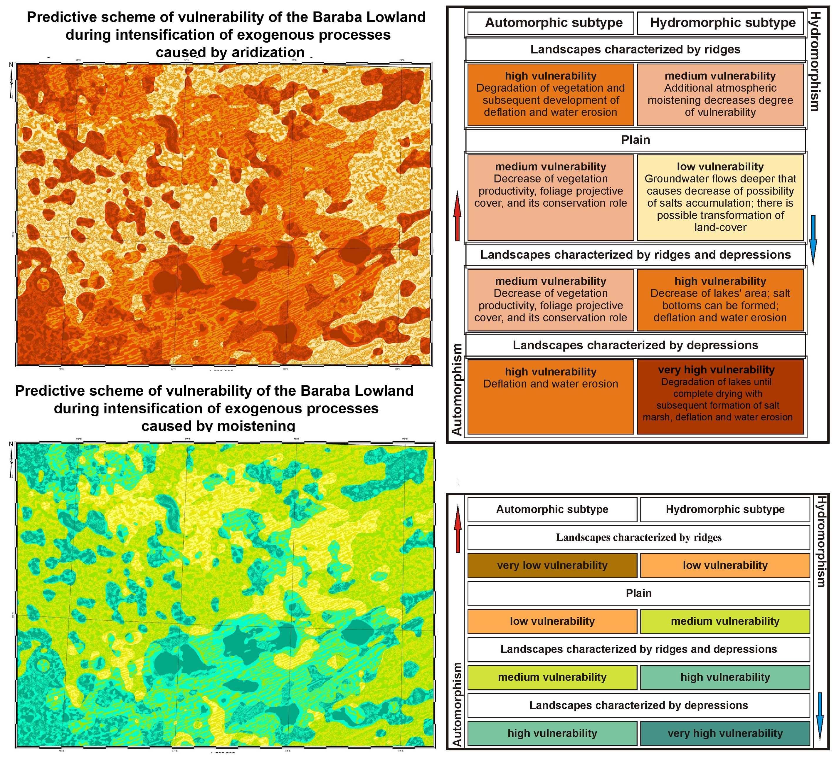
- Geological structure determines spatial distribution of potential environmental changes of Baraba lowland caused by dynamics of atmospheric moistening (humidification–aridization of climate).
- Aridization is the most dangerous process in comparison with potential moistening for the South of Western Siberia and its agriculture.
- The results obtained allow us to clarify mosaic type of spatial distribution of landscape components transformation caused by climatic fluctuations for the South of Western Siberia.
- The proposed methodology can be applied to predict development of negative processes and events for regional and local levels, and to develop preventive actions to decrease possible damage.
This paper is concerned with the presentation of the methodology to GIS mapping of the territory according to degree of vulnerability to aridification/humidification processes. The methodology is based on combination of different thematic information, such as paleogeographic, landscape, archaeological, geobotanical, with characteristics of the geomorphological framework built by using of the digital elevation model SRTM (Shuttle Radar Topographic Mission). The area under consideration is located on the Baraba Plain, which has close to the surface position of groundwater. The interrelation between the parameters of landscape and moistening (ground and atmospheric) was considered through the concept of automorphic and hydromorphic lands, on the basis of the indicator of relative elevation derived according to a digital elevation model. Two models of vulnerability of the territory were built by using this indicator for four landscapes (with ridges, lakes, ridges and lakes, and plain) for aridification and humidification cases. The obtained results show areas, which are the most vulnerable to activation of exogenic processes dependent on climatic changes. The study concluded that automorphic surfaces are less vulnerable to humidification and more vulnerable to aridification. At the same time, hydromorphic areas of all types of landscape are vulnerable to both humidification and aridification. Thus, aridification is the most dangerous trend for the south of the West Siberian Plain. The novelty of these models is the ability to assess the degree of transformation of terrestrial ecosystems simultaneously over the entire area and locally for each of its sites at the medium-scale level of research. The proposed methodology allows correcting predictive models and paleo-geographic reconstructions depending on landscape features of the territory.
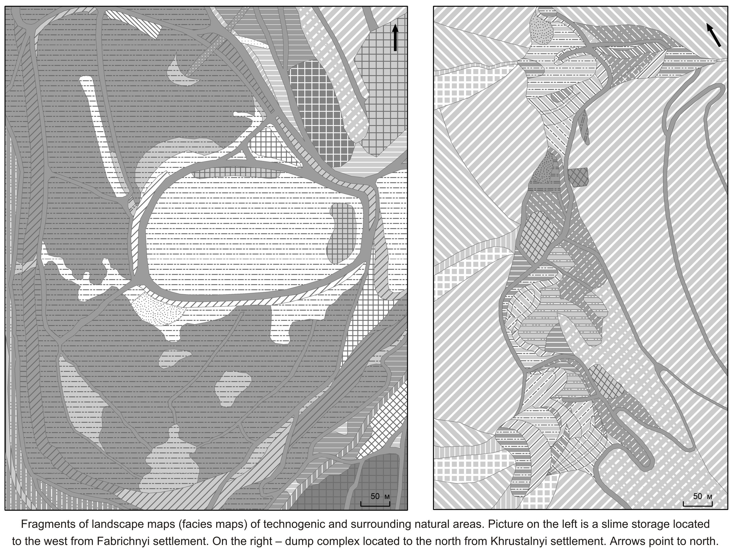
- Classification of anthropogenic geographical facies is developed very poorly.
- A sequence of naturalness–artificiality of geocomplexes: natural → techno-natural → natural-technical → technical.
- Mining led to the formation of industrial, road and other geocomplexes in the region.
- There is a need for clearer criteria for classes of different ranks.
F.N. Milkov mentioned that preparation of regional description, development of classification and mapping of anthropogenic landscapes are the most important tasks for anthropogenic landscape science. Currently, the relevance of these tasks has only increased as the insufficient development of the classifications of anthropogenic geocomplexes/geosystems is a factor that significantly depleting the contents of various (universal and specialized) informational and informational-analytical systems. So, the task of this article is to develop a classification of micro-landscapes (geographical facies) for the creation of detailed landscape maps and for the subsequent differentiated monitoring of the mining territories of the Sikhote-Alin biosphere area and surrounding regions. The mining in the Sikhote-Alin biosphere area determined the formation of several very different classes of anthropogenic landscapes. First of all, these are industrial geocomplexes. Residential, transport, agricultural geocomplexes were formed and developed largely under influence of the mining. It is revealed a great diversity of micro-landscapes, which belong to eight classes (orders) of the highest rank: technical terrestrial, natural-technical terrestrial, natural-technical amphibious, techno-natural terrestrial, techno-natural amphibious, techno-natural aquatic, natural terrestrial, natural amphibious. Existing classifications of anthropogenic geocomplexes/geosystems mainly developed by the inductive method, usually in the process of mapping. Apparently, when coverage of a wide range of micro-landscapes – from natural and techno-natural to natural-technical and technical – universal criteria for separation of classes of the same classification rank can be formulated only in general terms. More operational criteria should be specified within the individual classes. In the proposed classification of micro-landscapes (geographical facies), the classification criteria are defined quite clearly for some classes. Maps of micro-landscapes for two key areas covering a technogenic “core” and a natural surrounding area are presented.
View of a Geographer
We discuss the concept and term of landscapity (fr. рaysagéité, germ. Landschaftlichkeit, russ. ландшафтность), which is not so long ago appeared in the conceptual apparatus and the lexicon of geographers, architects, philosophers. The concept of landscapity arises as a kind of semantic expansion of the concept of landscape, resulted from a) historically established epistemological properties of the concept of landscape, b) the current situation of postmodern with its accompanying proliferation of the concept of landscape, c) understanding of the landscape as a supercomplex phenomenon of existence. Those new methodical, methodological and epistemological aspects, the possibilities of landscape geography, which can be formed on the basis of the concept of landscapity, are shown on specific examples, as follows: interpretation of the landscape as a machine in the understanding of G. Deleuze and F. Guattari and the use of the concept of landscape in the exact sciences; theoretical-multiple understanding of the landscape; extremely complex, does not fit into the established tradition of geographical science, existential and axiological contexts of modern landscape studies, in particular, the difficulty of methodically unified (joint) consideration of such landscape antipodes as cultural landscape and landscapoid.
International Cooperation of Geographers
- The state of contemporary geographical studies in Russia and the world was considered.
- The themes of 11 keynotes comprised the role of greenhouse gases in climate change and its impact on the conflicts in Africa; patterns of birds’ transcontinental migrations; geographical analysis of global foreign trade flows; geographical education.
- The concept of green development in different natural and socio-economic conditions was discussed, including the context of China’s Belt and Road Initiative.
- New light was shed on the correlation between the observed rise of temperature and precipitation in non-tropical areas and the results of modelling.
- Participants of the conference discussed the changes in territorial governance at the local level during the last 25 years in the context of centralisation and decentralisation in different world regions, including Russia.
This paper is an overview of the IGU Thematic conference “Practical Geography and Challenges of the XXI Century” dedicated to the centennial of the Institute of Geography of the Russian Academy of Sciences and held in Moscow on June 4–6, 2018. The conference gathered over 750 participants from 37 countries. Its vast scientific program was in particular focused on adaptation of nature and society to climate change. Much attention was paid to such themes as urbanization and urban geography, population mobility, the developments in polar areas, water resources and their use, political geography and border studies, the perspectives of mountain territories, the organization and the functioning of natural parks and reserves. Special symposia were devoted to the formation of “Big Eurasia” and the implementation of Chinese “One Belt – One Road” initiative, and to geographical education shaping the knowledge and skills vitally important for citizens of the XXI century. The papers submitted to the conference concerned the territories of different size, which corresponds to the multi-scale character of geographical problems and approaches used in contemporary geographical studies.
Surveys and reviews

- In Russia the network of polar stations for long-term environmental monitoring is poorly developed.
- Land geodetic method allows to receive data on ecosystems components in cloudy conditions.
- The projective covering of vascular plants considerably decreases from sub-arctic to arctic tundra zone.
- Distribution of the land cover on the Belyi Nos Cape depends on drainage conditions and is limited by cryogenic processes.
- Distribution of the major vegetation communities on the Flora Cape is determined by altitudinal gradient and slopes steepness.
According to the results of land-based cartographic-geodetic works in the Barents/Euro-Arctic region, the opportunities of its use as a tool for operational fixation of the current state of landscape cover during unpredictable synoptic situation are shown. The expediency of the use of geodetic survey as the only possible method for creating a geospatial basis of the territory in conditions that limit receiving high-precision data by using remote geographical measurements is confirmed. The systems of measures and strategies for the sustainable development of the Arctic states aimed at a comprehensive scientific study of the region with the use of land-based and remote methods are described. The regularities of landscape cover organization on the key areas (the Flora Cape – the Franz Josef Land Archipelago and the Belyi Nos Cape – the Nenets Autonomous Okrug) are revealed during the large-scale (1:500) geodetic survey conducted by the authors in the 2015 summer season during the scientific rout on the research vessel Professor Molchanov within the Arctic Floating University international expedition. The new map data, which allow to estimate the localization of landscapes areals in cryogenic conditions, were created. The leading factors defining spatial and incomponent links in cryogenic landscapes at the local level are revealed. In the synthesis of data, the emphasis is made on the possibilities, advantages and disadvantages of the land-based cartographic-geodetic methods are used for the study of the Arctic territories.
Book review: Geography of the world economy: traditions, modernity, prospects / V.A. Kolosov, N.A. Sluka (Ed.). Collective monograph. Smolensk: Oikumena, 2016. 400 p.
Book review: YablokovSad. Memories, reflections, forecasts / D.N. Klado (Ed.). Moscow: VegaPrint, 2018. 512 p.
ISSN 2658-6975 (Online)


