

Territorial Organization of Society
- In the period 2011–2016, the net income of citizens were decreasing in most of the Eastern regions of the Russian Federation.
- The spatial heterogeneity of net income remains exceptionally high.
- The dynamics of net income in the Far East are generally more positive than in Eastern Siberia.
- Despite favourable conditions for cross-border relations, the level of net income in the East of the country is not growing.
- The problem of creating favourable conditions for preserving population in the Eastern border region is no closer to its solution.
One of the main problems hindering the development of the territories adjoining state boundary in the east of Russia is the population outflow-mainly departure of educated, young and active citizens. Among its reasons are territorial differences in the level and quality of life. The indicators of dynamics of net income (adjusted for price increases in Russian regions) of citizens legally employed in various industries and sectors, were chosen as quantitative characteristics of the interregional differentiation factors. The period from 2011— from the time of economic stabilization after the crisis of2008-2009-to 2016 was considered. Processing and analysis of official statistical information were carried out using GIS technologies; the results are presented by thematic maps of the spatial distribution of the studied indicators in the regions of the Russian Federation. Crises and economic shocks undoubtedly had a significant impact on the regions’ economy, however the degree of sensitivity to them (determined by socio-economic policy) was highly heterogeneous. The policy of import substitution has had a positive impact on the agricultural sector, and in most Russian regions the net income of rural workers has increased significantly. Citizens net incomes in the agro-industrial complex remain low, the share of people living in rural settlements in the eastern border regions is quite high, so it is necessary to state that the geopolitical problems in the East of the country are still far from being solved. As a result of processing and analysis of a large data array, it was found that the dynamics of net income of employees in the economy in the Far East is generally more favorable than in Eastern Siberia, although there are significant sectoral differences.
- Geospaces of religions transform through expansion and/or contraction.
- In the 20th and 21st centuries, the confessional space of Africa was changing primarily due to the intensive expansion of the geospace of Christianity, weak expansion of the geospace of Islam, and contraction, followed by fragmentation of the geospace of ethnic religions.
- Until 1990, the geospaces of Christianity and Islam expanded independently from each other. Currently, they actively interact within the Sudan–Sahel belt.
The paper demonstrates the main finding of the research examining the transformation of Africa’s religious geospace and its constituent geospaces of the region’s largest faith groups in the 20th and the beginning of the 21st centuries. In aim of analyzing this process the methodology has been developed. It allowed us to conduct a comprehensive assessment of the religions’ geospaces changes. It examines their territorial structure inertia, the degree of their territorial concentration, direction and speed of their demographic centers’ movement. Established that the religious space of a territory as a combination of the geospaces of individual religions which interact with each other, can undergo transformation that appears in two multidirectional processes. They are manifested in expansion and compression of religious geospaces, generally separated in time by a state of rest-the stage of territorial stabilization. The transformation of the religious space of African countries was due to the changes of the religious structure types, which are defined on the bases of the share of the replaced religion in the model of religious competition. The revealed geographic pattern of these changes indicates the centrifugal multi-focal nature of the Africa’s religious space transformation. Having emerged in an initial territorial cell Christianity and Islam spread within the neighboring territorial cells, determining the nature of the ethnic religions’ geospace compression-firstly contiguous and then fragmented. The active interaction of Christianity and Islam’s geospaces in Africa de facto began only after 1990. It arose mainly within the countries of the Sudan-Sahel belt, before that their territorial expansion had occurred independently of each other.
- Poles of inaccessibility are the points on uninhabited territories as far as possible from infrastructure.
- Around the poles are formed areas of inaccessibility, bounded by infrastructure facilities.
- Areas are of various scales: municipal, regional, national/continental, and planetary.
- A natural recreational system is a combination of areas of inaccessibility, tourists and regulatory authorities.
- The recreational potential of the natural recreational system is determined as: Pnrs = E + A + C + R + L, where E stands for economic activity, A is accessibility, C is climate, R is relief, and L is landscape attractiveness.
In uninhabited territories points are allocated—the poles of inaccessibility—maximum remoted from any infrastructure. Around them the areas of inaccessibility are formed, on all sides limited by different infrastructural objects. The poles of inaccessibility can be allocated to different scales: municipal, regional, national-continental and planetary. In each of them there is a special system for organizing recreation. The set of elements of recreation, which are different in function, determines the recreation in the areas of inaccessibility and constitutes the natural recreation system. It reflects interaction of tourists and recreationists, unpopulated natural territories and controlling bodies that register, search and rescue tourist groups. In the article the formula to calculate the recreational potential of the natural recreation system was formulated. It takes into account economic activity, accessibility, climate, relief, and landscape attractiveness. The maximum value of natural recreation system’ potential is equal to 20 points (each criterion of five may have a maximum value of 4 points). The areas of inaccessibility of the microlevel surrounding Perm were studied. Their recreational potential of the natural recreation system was 14 points, which corresponds to the average level. The area of the inaccessibility of the Perm krai was also investigated. Its recreational potential ranged from 13 to 17 points, which corresponds to the average and high levels. Using the formula and GIS technology allows to determine territories for development recreational and tourist activities and creating protected natural areas.
Theory and Social Functions of Geography
- Geosystems change likely towards the systems that are functionally isomorphic, i.e. similar in primary bioproductivity or parameters of the descending branch of metabolism.
- Under the predicted thermo-arid trend in the next 100 years, forest biogeosystems in the transitional zone between forest and steppe in the European part of Russia will lose stability. A progressive steppe expansion on the forest areas is expected.
- Some forest formations, mainly taiga and subtaiga, contribute to positive regulation of the carbon cycle while others, such as nemoral and forest-steppe, contribute to the negative regulation.
- According to the relationship between carbon balance and sustainability of forest biogeocoenoses, five types of their functional states were identified: degradational, adaptive, optimal, suboptimal, and pessimal.
The author’s paradigm of experimental geographical ecology and its core-landscape ecology—has been set forth. The empirical statistical models and the ecological geographical concepts developed on their basis are described. They disclose the mechanisms of formation of regional- and local-level landscape-ecological systems, their natural and anthropogenic dynamics and evolutionary trends. New provisions on the mono- and polysystemic organization of the geographical environment have been put forward and substantiated: 1) environmental principles and mechanisms for the formation of zonal geospace and its borders; 2) the concept of polymorphism of landscape-zonal systems as a basic model for the further development of integrated physical geography; 3) a paleo-forecasting concept that describes the predicted scenarios and their paleogeographic analogues as a single system of global changes in the environment; 4) topo-ecological forecasting concept as a scientific and methodological basis of local geosystem monitoring; 5) new provisions of the theory of sustainability of natural ecosystems and methods for calculating their functional stability based on the parameters of the biological cycle. A methodology for numerical landscape-ecological forecasting developed by the author and brought to the prescription level is presented, and regional and local landscape-ecological forecasts are given based on forthcoming global climate changes. The predictive ecological analysis was performed by models of base states of the geo(eco-)systems and there climatogenic changes, with application of methods of empirical simulation techniques for the estimated prognostic situations. A strategy is proposed, and algorithms are developed for applying landscape ecology methods for quantitative forecast estimates of the biotic regulation of the carbon cycle under global climate changes. In the constructed models, geographical ecology acquires an effective formalized tool for analysis and prediction using the methods of discrete mathematics for the processing and generalization of bulk empirical data obtained from field and laboratory landscape studies.
Natural Processes and Dynamics of Geosystems
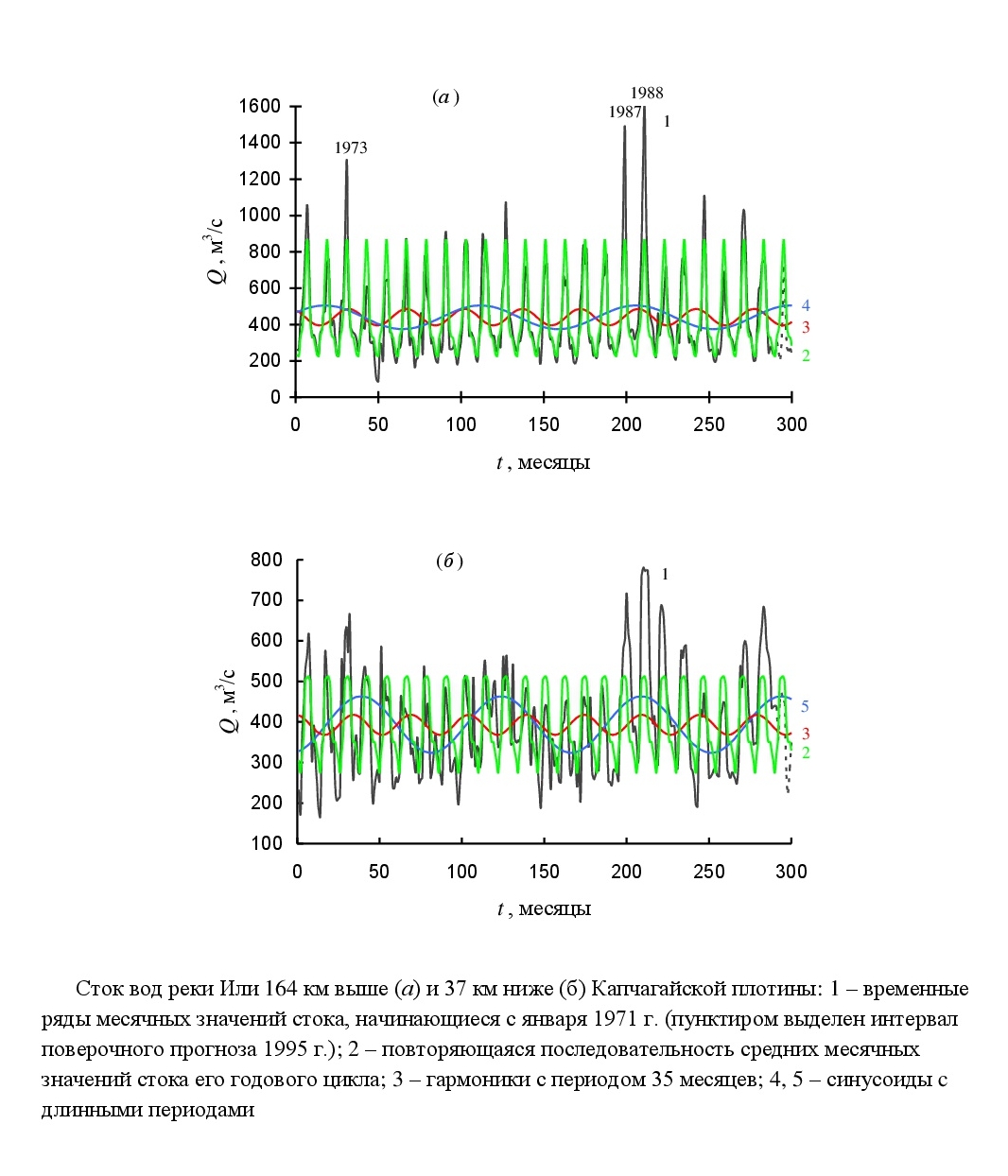
- Analysis of the variation in time series of monthly values of the Ili River runoff reveals periods of different lengths.
- Among them, the periods, found in the runoff variations upstream and downstream of the Kapchagayskaya Dam, are more reliable.
- The harmonics were applied for the modelling and prediction of the monthly and annual runoff values.
- Accounting for the annual cycle of the runoff improves the forecasts of monthly values.
Analysis of fluctuations in the time series of Ili River runoff monthly values for 1971-1994 was carried out using the method of “Periodicities” on the posts located 164 km upper and 37 km lower Kapchagayskaya Dam. The analysis revealed in fluctuations of each of them nine harmonics with the periods’ length larger than 1.5 years. The revealed sinusoids and repeating successions of runoff annual cycle’s mean monthly values were applied in different runoff prediction schemes for months and totally for 1995. Training forecasts’ results were estimated by the new independent data. Runoff regulation by the reservoir causes some reduction of its mean value, smoothing and losing its annual cycle rhythm. Long term periods are revealed more distinctly in the runoff variation lower the dam. In spite Kapchagayskaya Dam influence the harmonics with the same periods of 25 and 35 months were revealed in both time series among other sinusoids. Possibly they are more reliable, and it is more expedient to apply them for future runoff estimation comparing with sinusoids whose periods were proved only in one of time series. The Ili River runoff in 1995 upper the dam was extreme small. Lower the dam the runoff was close to the mean value of its time series. By the maj ority of applied predictions’ schemes results for the runoff upper the dam were better its estimations for future by the mean value of time series. Forecast’s mistake lower the dam was smaller than its acceptable value. Therefore, the forecasts computed by these schemes for months and for the annum at total could be estimated as satisfactory and quite acceptable.

- The present research deals with the western karst areas in Cuba.
- The research is based on the genetic theory of run-off and the linear-correlation model.
- As one of the results, the study presents a chart showing the influence of karst on the run-off and water balance.
The process and conditions of karst formation and its types have already been studied. As this natural phenomenon is heterogeneous and changeable, it is rather difficult to estimate how karst influences the river runoff, infiltration capacity and water balance in catchment areas. This study is based on the approach used by the author in his researches on water balance. The approach helps to estimate how karst influences infiltration capacity. The study is also based on the genetic runoff theory, firstly introduced by A.N. Befany. This theory takes into account the conditions of water absorption into soil when considering water balance. That is why it suggests three types of absorption: seepage within the period of water formation RT, seepage after termination of runoff due to amounts of water which are left in depressions R0, seepage within the period of runoff recession after water formation RT. In order to consider the influence of karst on hydrological characteristics, this study uses the values of surface detention depth after termination of runoff due to amounts of water left in depressions R0. This parameter is the key parameter in this study as it helps to estimate the influence of caverns on infiltration capacity. However, the amount of water detained in closed depressions R0 can partly include both surface runoff and water detained in caverns. This study helps to distinguish these two types of water. The article also shows the graph dependence between the cavern volume filled with water and infiltration capacity. This dependence makes it possible to estimate how karst influences infiltration capacity and runoff and water balance as well. The analysis helps to determine quantitative influence of karst on infiltration capacity. The results of the research must be considered as preliminary ones as it is necessary to analyze more catchment areas, using observation data from the Pinar del Rio and Matanzas provinces.
- An assessment of heat waves for the middle of the 21st century was made according to the data of the INMCM4 model.
- Under the ‘soft’ scenario, the growth of extremely hot days is expected in the south of European Russia and Western Siberia, in Yakutia and Primorsky Krai.
- Under the ‘hard’ scenario, the maximum temperature of the heat waves in the southern regions exceeds 40 °C.
- In the middle of the 21st century, an increase in absolutely unfavourable heat waves is possible.
The assessment of heat waves’ number, intensity and duration change during summer (June-August) in the Russia territory for the “historical period” (1980-1999) and for the middle of the 21st century (2046-2055) was made according to the data of the global climate model (INMCM4) of the Institute of Numerical Mathematics, Russian Academy of Sciences. The definition of the extreme events’ criteria depends on the thresholds’ choice. In this paper, heat waves’ thresholds are considered as the values of the 95th percentile of maximum daily temperature distribution. An increase in the number of days with maximum temperatures exceeding the threshold values for the south of the European Russia and Western Siberia, Yakutia, the north of Chukotka, and Primorsky krai in the middle of the 21st century according to the “soft” scenario of RCP4.5 was revealed. Maximum changes are expected in Taimyr and Yamal. In the rest of the territory, the number of such days will be reduced. For the “hard” scenario of RCP8.5, more contrast changes in the similar locations are expected. Under the “hard” scenario, by the middle of the 21st century the maximum temperature in the heat wave will exceed 40°C in the south of the country.
- Using wavelet analysis, temporal patterns of the hydrological signal were determined.
- A periodically correlated stochastic model of the variations of river runoff is discussed.
- A correlation between the runoff values within the year is significantly stronger in comparison to that of the interannual values.
This article examines the strength of perennial fluctuations’ relationship in monthly and annual runoffs in the Ural River basin. The norms of monthly and annual runoffs were calculated for the rivers of this basin. Using the wavelet analysis method, trends of their changes and water flow cycles were identified. An estimation of the river flow spatial correlation within the studied river basin was made. On the basis of a periodically correlated process model, the time series was predicted for the selected hydrological seasons. The relationship strength between the monthly average discharge of each month and the average annual water discharge, as well as between the average monthly water discharges were estimated. The statistical significance of the identified correlations was determined. A significantly stronger correlation between the values of the runoff within the year in comparison to that of the interannual was established. The last finding may be due to the long-period oscillation presence in the temporal series that helps manifest the rhythm of the annual and intra-annual cycles. It is proposed to consider the runoff fluctuations in the Ural River basin as a random stochastic process consisting of two components: inertial (trend) and seasonal (oscillating).
Evolution of Natural System
- The humus profile of automorphic Chernozems in the climatic cycle of the glacial–interglacial epochs was characterized by exponential Holocene development.
- A shorter period of development was characteristic for the second zonal component of forest-steppe soils, Grey Forest Soils (Luvisols), formed from Chernozems as a result of late Holocene cooling and forest expansion on steppes.
- The alternation of the intra-centennial quasi-30-yrs cool–humid and warm–dry phases of the climate led to dynamic changes in the ranges of soils, primarily mochars, the level of groundwater, and the area of swamps.
- The development of each of them was characterized by different time in occurrence and had its own mean characteristic time.
The responses of the natural environment components to climate change of different periodicity in the South of the Central Russian Upland were studied. The modern interglacial period in the climatic cycle of the “glacial—interglacial” epochs is considered as the reflection of the Holocene self-development of the upper humus part of the chernozems’ profile. Less long period of self-development of zonal soils of the forest-steppe is substantiated for the profiles of automorphic gray forest soils of the region. These soils formed from chernozems due to the late Holocene cooling and the forests invasion on the steppes caused by it. The changes of natural environment components (soils, ground waters, swamp ecosystems) in heat—dry and cool—wet phases of intra-centennial climate changes (Brickner cycles) are compared. These changes were revealed based on the analysis of 127-year series of meteorological observations at the reference climatic station Bogoroditskoe-Fenino. The conceptual scheme of cyclical phenomena (increase of groundwater level, flooding, bogging, appearance of hydromorphic properties in soils, etc.) in connection with the intra-century climatic variability is proposed. The scheme’s important methodological principle is the different age and different characteristic times of development of processes and phenomena forming the study area geosystems under the climate change influence.
- An overview of the dendrogeomorphological methods for studying past geomorphic events caused by gravitational mass movements, presented in international journals.
- The methods are described stage by stage from preparation to identification, dating, and reconstruction of debris flows, snow avalanches, and rockfalls.
- Advantages, limitations, and problems of the methods at all the stages of a study are a focus of the overview.
- One of the main unsolved problems is an assessment of the intensity of events by qualitative and quantitative criteria.
Since the beginning of the 21st century dendrogeomorphological research are abruptly activated in Western Europe but are appreciable reduced in Russia. In the present foreign literature, the new methods and approaches of dendrogeomorphological research has been developed and discussed. The article goal is an overview of the dendrogeomorphological methods for identifying, dating and reconstructing the geomorphic events (debris flows, avalanches, rockfalls), their advantages and limitations at different stages of a dendro-geomorphological study. The dendrogeomorphological research are based on the J. Shroder’s “process— event-response” concept. The disputable questions and unsolved issues of the dendrogeomorphology are considered.
Natural Recourse Use and Geoecology
- A new approach has been developed to assess the water quality of the Eastern Donbass’s rivers located in the area of influence of the existing and liquidated coal-mining facilities.
- The approach is based on the use of two criteria: (1) the total water pollution index calculated relative to the hydrochemical background, and (2) the level of water toxicity based on the results of bioassay.
- The river water quality in the region (the Seversky Donets and Tuzlov river basins) varies from ‘low-polluted’ to ‘heavily-polluted’ with a negative tendency in the Tuzlov basin.
For the first time a new approach has been developed to assess the water quality of the Eastern Donbass rivers in the zone of man-made mine waters’ influence. The approach is based on the data of hydrochemical studies and surface water toxicity assessment by the results of biotest analysis. The approach basis is the use of regional background, a complex of hydrochemical and biotest data on a set of biotesting. The scale of water quality integrated assessment with the allocation of 5 classes has been developed. The rating scale takes into account water pollution degree according to analytical data and toxicity degree, including options for combining the results of the three bioassays. Water quality assessment results showed that within the Seversky Donets and Tuzlov basins it varies as a whole from the 2nd class (“slightly polluted”) to the 4th class (“heavily polluted”), according to the toxicity level-from 1st class (“conditionally non-toxic”) to the 3rd class (“toxic”). Analytical methods data are not always consistent with biotest analysis results, which is associated with different bioavailability of pollutants to biome. The final river waters quality assessment should be carried out taking into account the waters class according to hydrochemical data and with indication of the possible toxicants’ bioavailability for aquatic organisms.
Geoinformation Systems and Mappings
- Geolocated photos are a new data source for research in behavioural, cultural, aesthetic, and other areas of geography.
- The majority of the research with image geolocation analysis is presented in the geography of tourism.
- For large-scale studies, not only geolocation data is analysed, but also the images, descriptions, and tags.
The article presents an overview of geographical studies analyzing the spatial distribution of photographs points’ coordinates. These photos were uploaded by users on various open Internet resources: photo sharing, social networks, etc. Approaches to the classification of this kind of geographical research on the coverage of the territory, thematic focus, methodological principles are described. Naming of geotagged photos in the scientific literature are analyzed. Identified several thematic areas of research, where users’ geotagged photos are the study object. Their features are described. Examples of the researches conducted based on the photogeolocations’ analysis are given in different branches of geographical science: geography of tourism, behavioral geography, aesthetic geography, cultural geography, and others. The conclusions relate to the possibilities and features of the use of such data source as photographs’ geolocations in geographical research, as well as the prospects for such research for the Russian territories.
International Cooperation of Geographers
- Cooperation between Russian and French geographers in urban studies lasts for more than 40 years.
- It is based on a similar ideology of state regulation and methods of territorial planning.
- There are important differences in the definition and the delimitation of urban agglomerations.
- One of the most salient problems today is the relation between competitiveness of cities and social justice.
- The expansion of green spaces in cities can carry serious risks, as they increase fire hazard.
A session of the international conference devoted to the centennial of the Institute of Geography of the Russian Academy of Sciences (Moscow, 4-6 June 2018) was dedicated to the celebration of the 40th anniversary of the official French-Russian cooperation in urban geography. It was set up in the 1970s by the Institute of Geography, USSR Academy of Sciences, the Central Institute for Urban Planning, on the one hand, and the University Paris X Nanterre (Laboratory of Urban Geography), on the other. The cooperation was interrupted in the early 1980s before perestroika but resumed and led to a number of publications in Russia and France. The objective of the paper is to summarize the experience of the long-term cooperation between Russian and French geographers in urban studies and to consider some contemporary problems in this field in two countries.
ISSN 2658-6975 (Online)


